 Bacon's Map of Cumberland

|

|
|
|
map type:- Bacon c1890s |
|
|
|
Railway map, Bacon's Map of Cumberland, scale about 3.5
miles to 1 inch, by G W Bacon and Co, 127 Strand, London,
about 1890s?
|
||
|
(map example private collection (41))
|
||
| map feature:- | mounted & folded (5x3) & card covers & up is N & scale line & lat and long scales & sea plain & coast line & coast tinted & rivers & lakes & relief & hill hachuring & parks & county & electoral data (by colouring divisions and boroughs) & settlements & roads & railways & canals | |
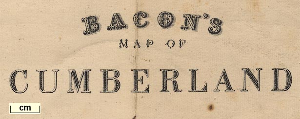
| inscription:- |
printed lower right
BACON'S / MAP OF / CUMBERLAND |
|
| inscription:- |
printed bottom centre
LONDON. G. W. BACON & CO. 127, STRAND. |
|
| wxh, sheet:- | 45.5x49.5cm | |
| wxh, map:- | 424x470mm | |
| wxh, folded:- | 9.5x17cm | |
| wxh, cover:- | 10x17.5cm | |
| scale line:- | 10 miles = 75.4 mm | |
| scale:- | 1 to 210000 ? (1 to 213441 from scale line) | |

|
||
|
||
| sources:- |
private collection |
|
| items seen (illustrated items in bold):- | ||

|
private collection (41) -- railway map -- Bacon's Map of Cumberland | |