 Map of Furness

|

|
|
|
map type:- Atkinson 1840s-50s |
|
|
|
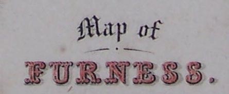
Map of Furness, scale about 6 miles to 1 inch, engraved
by W H Lizars, Edinburgh, published by David Atkinson,
Ulverston, Lancashire now Cumbria, 1840s-50s.
David Atkinson was active in Ulverston by the 1840s; W H Lizars died in 1859. |
||
|
(map example (in a bookshop))
|
||
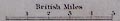
| map feature:- | up is N & scale line | |
| inscription:- |
printed lower right
Map of FURNESS |
|
| inscription:- |
printed bottom centre and right
Published by D. Atkinson, Ulverston. / Engd. by W. H. Lizars. Edinr. |
|
| inscription:- |
printed over scale line
British Miles |
|
| scale line:- | 5 miles = 21.5mm (roughly) | |
| scale:- | 1 to 370000 ? (from scale line assuming a statute mile) | |
| wxh, map:- | 9x15cm | |
|
||
| sources:- |
private collection |
|
| items seen (illustrated items in bold):- | ||

|
private collection (54) -- map -- Map of Furness | |