 Map of the Lake District

|

|
|
|
map type:- Adams 1852 map |
|
|
|
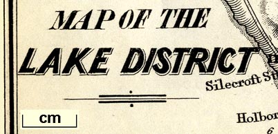
Map of the Lake District, published by W J Adams, 59
Fleet Street, London, 1852.
Tipped in opposite p.iii in Adams's Pocket Descriptive Guide to the Lake District. |
||
|
(example Armitt Library : A1117.2)
|
||
| map feature:- | folded (1x3) & up is N & sea plain & coast shaded (on land side) & rivers & lakes & relief & hill hachuring & spot heights & parks & county & settlements & roads & railways & canals & geology | |
| inscription:- |
printed lower left
MAP OF THE / LAKE DISTRICT |
|
| wxh, sheet:- | 21.5x16cm | |
| wxh, image:- | 190x152mm | |
| sources:- |
Armitt Library |
|
| items seen (illustrated items in bold):- | ||

|
Armitt Library : A1117.2 -- map -- Map of the Lake District | |