 Smith 1804

|

|
|

|
back to object record | |
| MAP FEATURES | ||
|
|
||
|
title
map maker engraver |
Printed upper left:-
A NEW MAP of the COUNTY of WESTMORLAND Divided into Wards. LONDON Printed for C. SMITH No.172 Strand. January 6th. 1801. Printed beneath the compass rose, upper right:- Jones & Smith sculp. Pentonville |
|
|
|
||
| table of symbols |
Printed lower left is an:-
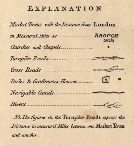
EXPLANATION Market Towns with the distance from London in Measured Miles as ... BROUGH / 261 3/4 Churches and Chapels ... [cross (+)] Turnpike Roads [double line, light bold] Cross Roads [double line, narrower, light light] Parks and Gentlemen's Houses ... [outline with fence palings and a block, and a block] Navigable Canals [triple line, light bold light] Rivers [tapering wiggly line] NB. The figures on the Turnpike Roads express the Distance in measur'd Miles between one Market Town and another. |
|
|
|
||
|
orientation
compass rose |
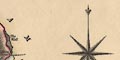
Printed upper right is a compass rose; no circle, star points for cardinal and half cardinal directions, North marked by a fleur de lys. The map is printed with North at the top of the sheet. |
|
|
|
||
|
scale line
scale |
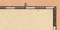
Printed lower right is a:-
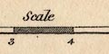
Scale ... Miles chequered and labelled in miles, chequered and labelled in furlongs on a left extension. The 8+1 miles = 98.6 mm gives a scale 1 to 147346 assuming a statute mile. The map scale is about:- 1 to 150000 2.5 miles to 1 inch |
|
|
|
||
|
lat and long
lat and long scales |
Printed in the map borders are scale of latitude and longitude for a rectangular projection.; chequered in minutes, labelled at 5 minute intervals. The bottom scale is labelled:- Longitude West of Greenwich Reading from the scales, the longitude, Kendal = 2d 47.25m W which is a little out from the longitude used today, 2d 44.8m W, but not outwith the likely errors of reading? As there is no 'degree' parallel within the county, the 15 minute N mark is labelled:- 54 [degree] 15 The map includes from 2d 2m to 3d 21m W, from 53d 11m to 54d 44m N; the whole of Westmorland. |
|
|
|
||
|
coast line
coast form lines |
The bit of coast line shown in the Kent Estuary is emphasised by form lines, tinted blue. |
|
|
|
||
|
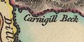
rivers
bridges ferries |
Rivers are drawn by a double line, light and bold, tinted blue, reducing to a single wiggly line tapering upstream. Some rivers are labelled, eg:- Ken River Underbarrow R. Crowdundle Beck Trout B. Waterfalls might be noticed, eg:- 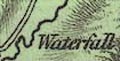
Waterfall ie Stockghyll Force, outside Ambleside. Bridges are implied where a road crosses and interrupts a stream. Some are labelled, eg:- 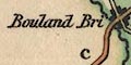
Bouland Bri. Mint Br. Lowther Bridge The road approaching Windermere lake south of Bowness is labelled:- Ferry |
|
|
|
||
| lakes |
Lakes are drawn in outline, with from lines. Larger lakes
are labelled:-
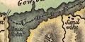
Angle Tarn Blea Tarn Broader Water [Brothers Water] Elter Water Grasmere Water HAWES WATER Hays water Mazon Wath [Sunbiggin Tarn] Rydale W. Skeggles Water The Tarn [Kentmere Tarn] ULLES WATER WINANDER MERE Other lakes and tarns can be recognised with more or less certainty:- Cunswick Tarn Easedale Tarn Fisher Tarn Grayrigg Tarn Stickle Tarn Terrybank Tarn Whinfell Tarn [? N of Farleton] [decoy pond, Lowther] [pond, Lowther] Some of these are very uncertain. A few islands are noticed, for example:- House Holme in Ullswater. |
|
|
|
||
|
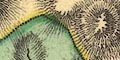
relief
hill hachuring |
Relief is indicated by hill hachuring, all over the
county. Some hills are labelled, showing a variety of
placename terminology, eg:-
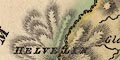
HELVELIN Place Fell DOW CRAGGS SILVER HOW SCORDALE HEAD Langdale Pikes Round Hill Farlton Knot Witherslack Scar Valleys might be labelled, eg:- Westledale Long Sleddale Langdale And a pass might be labelled, eg:- Nan Bield which is marked by a pillar. |
|
|
|
||
|
woods
forests trees |
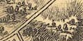
Woodland is indicated by groups of small mixed tree symbols. A wood, or forest which might not have trees, might be labelled, eg:- Flake Bridge Wood WHINFELL FOREST An individual tree might be noticed, eg:- Hart Horn Tree |
|
|
|
||
| parks |
Parks are drawn in outline with fence palings, the
interior filled with tree and bush symbols, perhaps with a
block for a great house, tinted green. The park might be
labelled, eg:-
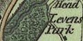
Levens Park Killington Park or might be named by its house, eg:- Rydale Hall |
|
|
|
||
| county |
The county boundary is a dashed line, also used to separate adjacent counties. The boundary line might not be shown where another feature serves, as along the Crowdundle Beck. Adjacent counties are labelled, eg:- CUMBERLAND There is a tint for each adjacent county along the boundary: Cumberland green, Durham Yellow, Yorkshire green, Lancashire yellow. Little is drawn outwith the county; the roads from Lincolns Inn Bridge and New Bridge through Sedbergh to Rother Bridge, for example. On a hill ENE of Kirkby Lonsdale a stone is drawn, labelled:- County Stone At the meet of three counties on Wrynose, three stones are drawn, labelled:- 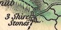
3 Shire Stones N of Grasmere is labelled:- Dummel Wray Stones Besides boundary markers quite a number of features, rivers, hills, bridges, etc, are clearly labelled on the county boundary. |
|
|
|
||
|
wards
table of wards |
Ward, comparable to hundred, boundaries are a fine dotted line. The ward areas are labelled with a number keying to a table, printed lower right:- REFERENCE to the WARDS 1 West Ward 2 East Ward 3 Kendal 4 Lonsdale Each ward has an overall tint, with a darker shade along the boundary: West yellow, East pink, Kendal green, Lonsdale yellow. The tint can obscure map features. |
|
|
|
||
|
settlements
distances from London |
Settlements are marked by a block or blocks, and perhaps
a cross for a church, differentiated by style of
labelling.
|
|
| towns |
blocks, perhaps a cross; labelled in italic block caps,
eg:-
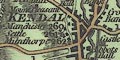
KENDAL / by Manchester 260 / Settle 261 3/4 / Milnthorp 262 AMBLESIDE / 274 1/2 BURTON in Kendal / 249 3/4 The figures are distances from London. The de jure county town is labelled in upright block caps:- APPLEBY / by Brough 270 / Kendal 284 |
|
| villages |
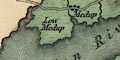
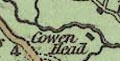
blocks, perhaps a cross; labelled in upright lowercase
text, eg:-
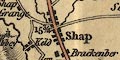
Shap Great Strickland Bowness [on Windermere] |
|
| hamlets |
block or blocks, perhaps a cross; labelled in italic
lowercase text, eg:-
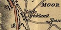
Little Strickland Keld Natland This style of lettering is used generally for map features. |
|
|
houses
castles |
Gentlemen's houses are noticed, marked by a block and
labelled, eg:-
Lowther + and Hall labelling and marking church and house. Castles might be marked by a symbol of two towers, etc, eg:- 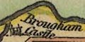
Brougham Castle |
|
|
|
||
|
roads
turnpike roads road distances |
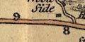
A network of roads is drawn by double lines; broader with light bold lines for turnpikes, narrower for lesser roads. Road distances from town to town are marked by a figure beside the turnpike roads at mile intervals, and possibly a mile and a fraction at a destination or intermediate village, as at Heversham or Milnthorp on the road to Kendal. Road distances do not always look equally spaced! for example follow the mile marks 4, 5, 6, 7, on the road from Kendal towards Sedbergh. Looking at the 1 mile marks on roads out of Kendal it is not clear where they are measured from. Exactness does not appear to be a feature of this map. Roads leaving the county might be labelled at the county boundary with their destination and a distance, eg:- from Kendal to Ulverston 20 Miles / c to Lancaster 11 Miles / b The distance might be from the boundary or between towns. The small letter presumably links to a corresponding letter on the same road in an adjacent county map in the series. Some toll gates are noticed, for example:- 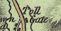
Toll Gate [at Town Head N of Grasmere] Toll Gate [W of Brough] |
|
|
|
||
| canals |
Canals are drawn by a triple line, light bold light. One canal is shown:- |
|
| Lancaster Canal |
drawn in a straight route from the south into Kendal,
ignoring the turns and the tunnel. Labelled:-
Lancaster Canal |
|
|
|
||
| miscellaneous | ||
|
|
||
| beacons |
On the hill NE of Barbon is a pillar labelled:-
Barbon Beacon On the S side of Whinfell Common is:- Beacon |
|
|
|
||
|
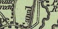
mines
coal mines |
South of Lune Forest are:-
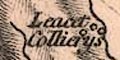
Leacet Collierys On the SE part of Stainmoor are:- Coal Pits |
|
|
|
||
|
mines
lead mines |
On Dufton Fell three circles are labelled:-
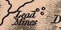
Lead Mines and on Mickle Fell in Lune Forest there is a:- Lead Mine |
|
|
|
||
| inns |
Some inns are labelled, eg:-
Punch Bowl [at Underbarrow] E of Brough on Stainmoor are:- 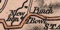
New Inn Punch Bowl across the road from each other. And there is the:- Lowood Inn |
|
|
|
||
| stones |
Various stones are noticed, for example:-
3 Shire Stones [on Wrynose] County Stone [on Yorks, Lancs, Wmd boundary] Dummel Wray Stones Nine Standards Ladys Pillar [by High Seat, SE boundary] Ladys Pillar [outside Penrith] |
|
|
|
||
|
chapels
meetings |
A number of chapels outwith any village are marked by a
cross and labelled. Particularly interesting is:-
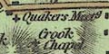
Quakers Meetg near Crook, whose chapel is not in the village, labelled:- Crook Chapel |
|
|
|
||
| blacksmiths |
At Patterdale there is a:-
Smithy |
|
|
|
||
|
antiquities
earthworks |
Near Eamont Bridge there are:-
K. Arthurs round Table Druids Temple |
|
|
|
||
|
antiquities
roman sites roman forts |
At Ambleside there is:-
Camp and more interesting, marked by a square of walls:- 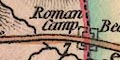
Roman Camp across the road from Brough to Boro' Bridge, at the county boundary. South of Kirkby Thore there is labelled:- Gallatum |
|
Lakes Guides menu.