 Simpson 1746 map

|

|
|

|
back to object record | |
| MAP FEATURES | ||
|
|
||
| labelling |
The labelling of the map is confused. It is not always easy to associate a particular label with a mark or symbol on the map. |
|
|
|
||
|
title
map maker |
A title is printed at the top:-
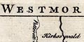
WESTMORLAND The title page of Simpson's book states:- ... With a Map of every County prefix'd to each, from the best and latest Observations, after the Designs of HERMAN MOLL, and others. ... The map has much the same detail as the map by Moll 1724. |
|
|
|
||
| coat of arms |
Printed upper left is a fake coat of arms:-
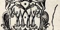
The Arms of Westmorland having two letter Ws interlaced. |
|
|
|
||
|
orientation
compass rose |
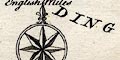
Printed lower right is a compass rose; double circle, star points for cardinal and half cardinal directions, North marked by a hybrid spear point fleur de lys. The map is printed with North at the top of the page. |
|
|
|
||
|
scale line
scale |
Printed lower right is a scale of
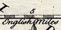
English Miles chequered in ones, labelled at 5 mile intervals. The 10 miles = 32.3 mm gives a scale 1 to 498249 wrongly assuming a statute mile. The map scale is about:- 1 to 500000 8 miles to 1 inch |
|
|
|
||
|
sea area
sea plain |
The small amount of sea shown is plain, labelled:-
THE IRISH SEA |
|
|
|
||
|
coast line
coast form lines |
The coast line is emphasized by form lines. |
|
|
|
||
|
rivers
bridges |
Rivers are drawn by wiggly line, excepting a few broader
reaches with a double line and perhaps stream lines. Some
rovers are labelled, eg:-
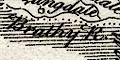
Brathy R. Leven R. Roads are engraved across rivers, sometime interrupting the stream.. sometimes not. There is nothing to suggest bridges in any regular way. Few bridges are labelled, eg:- 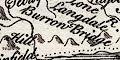
Burrow Bridge [Low Burrow Bridge] New Bridge [Newby Bridge] |
|
|
|
||
| lakes |
Lakes are drawn by an outline with form lines, perhaps
with islands. The following lakes are labelled:-
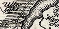
Ulles Lake Winander Mere Other lakes might be recognised, eg:- Brothers Water Easedale Tarn Grasmere Hawes Water Hayes Water Kentmere Tarn Rydal Water |
|
|
|
||
|
relief
hillocks |
Relief is suggested here and there by hillock symbols,
some a little larger. Their distribution gives little sense
of the shape of the county. A few hills are labelled,
eg:-
Kelloplaw Hill Hutton Morvel Hill Wildbore Fell which are on the county boundary. Also:- 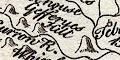
Gefferyes Hill Whinfield Hill |
|
|
|
||
|
woods
trees forests |
Some woodland is indicated by tree symbols, but it hard
to believe these are placed in a meaningful way. Some
forests are labelled, eg:-
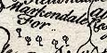
Markendale For. [Martindale Forests] Milburn For. |
|
|
|
||
| parks |
Parks are drawn by a ring of fence palings, the interior
perhaps having a few trees, and perhaps labelled, eg:-
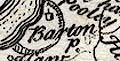
Barton P. Brigster P. Thornthwaite H. |
|
|
|
||
| county |
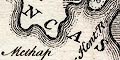
The county boundary is a dotted line, the outer side shaded. Adjacent counties are divided by dotted line and labelled, eg:- PART OF CUMBERLAND P. OF LANCASHIRE A scatter of rivers, settlements, etc, are drawn outwith the county. |
|
|
|
||
| settlements |
Settlements are marked by a circle, or a building or
tower symbol, or not marked, differentiated by style of
labelling.
|
|
| towns |
tower; labelled in upright lowercase text, eg:-
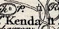
Kendall Orton |
|
|
villages
hamlets |
circle, or small tower, or nothing; labelled in italic
lowercase text, eg:-
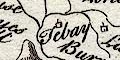
Tebay 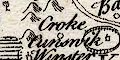
Croke |
|
|
|
||
| roads |
Roads are drawn by a double line, solid or dotted
suggesting fenced or unfenced, or maybe just better or
worse. The routes shown are:-
from the south, Lancashire; through Burton, Kendall, Shap, Westmorland; then Penrith and north west, Cumberland, on:- The Military Way from Kendall, through Minander Mere, Ambleside, Westmorland; then over Dunmail Raise pass to Keswick, Cumberland. from Ambleside, by the head of Hawes Water, Hartsop, Patterdale, Westmorland; to Penrith, Cumberland. 2 routes from the east, Durham; meeting at Brough, then through Appleby, near Kirby Thure, Westmorland; to Penrith, Cumberland. from Kirby Thure, Westmorland; north into Cumberland, the:- Maiden Way |
|
|
|
||
| miscellaneous | ||
|
|
||
|
mines
lead mines copper mines coal mines |
Marked by crosses (x) on the south of Milburn Forest
are:-
Lead Mines More mines are shown near Murton, and more in the North Riding of Yorkshire. In upper Langdale is a:- Copper Mines perhaps Goldscope Mine. On the south of Stainmoor is:- The Coal Pitt |
|
|
|
||
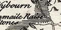
| stones |
No stones are marked, but a label south of Shap shows
where are the
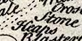
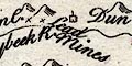
Stone Heaps and there is a label for the Dunmail Raise Stones |
|
Lakes Guides menu.