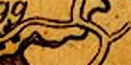
 Ruthven 1855

|

|
|

|
back to object record | |
| Map Features | ||
|
|
||
| map making |
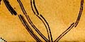
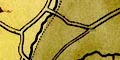
Notice the part of the map north and east of Penrith
where jiggles in the roads and railway are from inaccurate
paste up of parts of the image.
|
|
|
|
||
| map folding |
See:-
RUN2Mfd.txt |
|
|
|
||
|
title
map maker engraver publisher |
Printed upper right:-
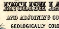
MAP OF THE ENGLISH LAKES AND ADJOINING COUNTRY GEOLOGICALLY COLOURED BY JOHN RUTHVEN OF KENDAL. 1855. Printed at the bottom left, right, centre:- Engd. by W. Banks. Edinburgh. / Entered at Stationer's Hall. / PUBLISHED BY JOHN GARNETT, WINDERMERE. ACKERMANN & CO. LONDON. Notice, in places, discontinuities in the drawing of map features. There are examples to the north and east of Penrith where there are 'faults' in the railway and roads. These look like places where the paste up of pieces of map, perhaps in a litho reproduction process? has been inaccurate. |
|
|
|
||
|
orientation
north point |
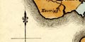
Printed lower left is a north point; N-S line, E-W cross line, North marked by a spear point. The map is printed with North at the top of the sheet. |
|
|
|
||
|
scale line
scale |
There is a scale line printed lower left:-
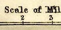
Scale of Miles marked and labelled at mile intervals. The 5 miles = 36.1 mm gives a scale 1 to 222901. The map scale is about:- 1 to 220000 ? 3.5 miles to 1 inch |
|
|
|
||
| lat and long scales |
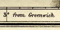
Printed in the map borders are scales of latitude and longitude for a trapezoidal projection; marked at minute intervals and labelled at tens. The bottom scale is labelled:- Longitude West from Greenwich. From the scales the longitude, Kendal = 2d 47m W which suggests, with poor accuracy, a prime meridian 2 degrees east of Greenwich; this is not a reliable indicator. The map includes from 2d 14m to 3d 48m W, from 54d 2m to 54d 56m N; Westmorland, Cumberland cut off north of Carlisle, and Lancashire north of the sands. |
|
|
|
||
| table of symbols |
Printed lower left is a table of symbols for some map
features:-
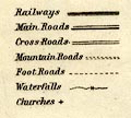
Railways [triple,line, light, bold, light] Main Roads [double line, light bold] Cross Roads [double line, light light] Mountain Roads [double line, dotted] Foot Roads [single line, dotted] Waterfalls [2 lines cross a stream] Churches [cross (+)] |
|
|
|
||
|
sea area
sea plain |
The sea area is plain. Some sea areas are labelled,
eg:-
IRISH SEA MORECAMBE BAY |
|
|
|
||
|
coast line
coast form lines headlands harbours foreshore |
The coast line is emphasized by form lines. Some headlands are labelled, eg:- Grune Pt. St. Bees Head Harbours are mostly ignored, but the harbour walls at Whitehaven are drawn and 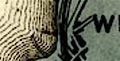
Piel Pier is labelled. The three important estuary sands are labelled:- Duddon Sands Leven Sands Lancaster Sands but are not marked. |
|
|
|
||
| rivers |
Rivers are drawn by a wiggly line, double with from lines tapering to single upstream. Some rivers are labelled, eg:- Leven R. Duddon R. Raven Beck Croglin W. |
|
|
|
||
| lakes |
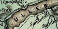
Lakes and tarns are drawn in outline with form lines. When looking for lakes do not be fooled by geological areas coloured blue. Some lakes are labelled:- Angle T. BASSENTHWAITE WR. Beacon Tarn Blea T. (Langdale) Blea Tarn (Borrowdale) Blea Wr. Bleaberry T. Blelham Tarn Bowscale Tarn Brothers Water Burnmoor Tarn BUTTER MERE Codale T. CONISTON WATER CRUMMOCK WR. DERWENT WR. Devoke Wr. Easedale T. Elter water ESTHWAITE WATER Floutern Tarn Goat Wr. GRASMERE LAKE Greendale Tarn Harrop T. HAWES WR. Hayes Wr. Keppel Cove Tarn Levers Wr. Lily Tarn Low Wr. LOWES WATER Over Water Red Tarn RYDAL WR. Scales Tarn Scales Tarn Seathwaite T. Skeggles Wr. Sprinkling Tarn Stickle Tarn Styhead T. THIRLMERE ULLES WATER WAST WATER WINDER MERE Other lakes or tarns might be recognized, eg:- Angle Tarn Blind Tarn Ennerdale Water [no form lines] Greycrag Tarn Grisedale Tarn lake, Aspatria lake, Cardurnock Little Tarn Loughrigg Tarn Low Birker Tarn [?] Low Tarn Mockerkin Tarn Monkhill Lough [?] Out Dubs Tarn Ponsonby Tarn [?] Red Tarn [by Wrynose] Scoat Tarn Small Water Thurstonfield Lough Watendlath Tarn |
|
|
|
||
|
relief
hill hachuring |
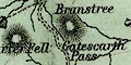
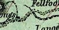
Relief is indicated by hill hachuring. Each hill is small, though some ranges of hills are shown, and the overall impression does not suggest a high mountainous district. Many hills are labelled, and some passes, eg:- Skiddaw Helm Crag Lord's Seat Caldbeck Fells Dod Fell High Pike Gatescarth Pass |
|
|
|
||
| forests |
Woodlands is not indicated but some forests areas are
labelled, eg:-
Copeland Forest |
|
|
|
||
| county |
County boundaries are not always very clear, but are shown by dot dash line, sometimes continued alongside a boundary feature. The county areas are labelled, eg:- WESTMORELAND |
|
|
|
||
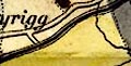
| settlements |
Settlements are marked by blocks or groups of blocks,
differentiated by style of labelling.
|
|
|
cities
towns |
group of blocks; labelled in upright block caps, eg:-
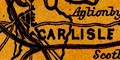
CARLISLE KESWICK ULVERSTON 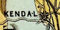
KENDAL |
|
| villages |
blocks; labelled in upright lowercase text, eg:-
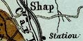
Shap Kirkoswald Hesket Newmarket |
|
| hamlets |
block; labelled in italic lowercase text, eg:-
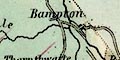
Bampton Aspatria Staveley Grasmere |
|
|
Italic lowercase is used for various other features.
|
||
|
|
||
|
roads
sands roads |
A network of roads and tracks is drawn by double and single lines, solid and dotted, wider and narrower. The roads are meant to be main and cross roads, mountain roads and foot roads, as explained in the table of symbols. When looking at the roads bear in mind the date of the map. |
|
|
|
||
| canals |
Canals are drawn by a bold curvy line. The Lancaster Canal and Ulverston Canal are shown. |
|
|
|
||
| railways |
Railways are drawn by a triple line, light bold light (which in other maps of the period and earlier is used for canals). Stations are [sometimes] marked and labelled. The following railways are shown:- |
|
| Newcastle and Carlisle Railway |
opened 1836-52.
from the east, into Carlisle, Cumberland. labelled:- Newcastle & Carlisle Railway |
|
| Maryport and Carlisle Railway |
opened 1845.
from Maryport, by Station at Birkby, Arkleby Station, Station at Aspatria, Heathfield Sta., Low Row Sta., Wigton, Curthwaite Sta., Sta. near Dalston, to Carlisle, Cumberland. labelled:- Maryport & Carlisle Railway |
|
| Lancaster and Carlisle Railway |
opened 1846.
from Castle Station, Lancaster, by Hest Bank Station, Carnforth Station, Lancashire; then Holme and Burton Station, Station at Milnthorpe, Oxenholme Station, Low Gill Station, Tebay and Orton Station, Statiou (sic) near Shap, Clifton Moor Station, Westmorland; Penrith, Plumpton Station, Southwaite Station, Station at Brisco south of Carlisle, to Carlisle, Cumberland. labelled:- Lancaster & Carlisle Railway |
|
| Kendal and Windermere Railway |
opened 1847.
from Oxenholme Station - junction with the Lancaster and Carlisle Railway, near Kendal, Station at Burneside, to Windermere, Westmorland. labelled:- Kendal & Windermere Railway |
|
| Whitehaven Junction Railway |
opened 1847.
from Maryport, by Flimby Station, Workington, Station at Harrington, Station at Parton, to Whitehaven, Cumberland. |
|
| Cockermouth and Workington Railway |
opened 1847.
from Cockermouth, to Workington, Cumberland. |
|
| Furness Railway |
opened 1848.
from Station at Broughton, by Station at Kirkby Ireleth, Station at Hawcoat, to Piel Pier, and from Hawcoat, by Station at Dalton, Lindal Station, to Ulverston, Lancashire. labelled:- Furness Railway |
|
| Whitehaven and Furness Junction Railway |
opened 1849-55.
from Whitehaven, by St Bees, Nethertown Station, Braystones Sta., Sellafield Sta., Seascales Station, Station near Drigg, Ravenglass, Eskmeals Sta., Silecroft Station, Station at Holborn Hill, [ ] Hill Station, Cumberland; junction near Broughton, Station at Broughton, Lancashire. labelled:- Whitehaven & Furness Junction Railway |
|
| Port Carlisle Dock and Railway |
opened 1854
from Carlisle to Port Carlisle, Cumberland. |
|
| Caledonian Railway |
?proposed.
from Carlisle north, Cumberland. labelled:- Caledonian Railway |
|
|
|
||
|
geology
stratigraphical column |
As its title declares, the map is coloured to show the geology of the area. Printed lower left is a stratigraphical column labelled with rock types (and not chronology). See:- RUN2Geo.txt |
|
Lakes Guides menu.