 Red Guide 1892 map

|

|
|

|
back to object record | |
| MAP FEATURES | ||
|
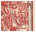
Published 74 years later, giving no credit to its origins,
the map is a clear copy of Jonathan Otley's map of 1818. The
differences that strike the eye immediately are: the sea and
lake areas are tinted a bold blue; railways are shown by
bold black lines; there is a piano key border; and the new
publisher's name is in the title cartouche. The map is
edited, fewer lakes are named, for instance. But the
geographical area shown is the same, the general content,
north point, diagram of mountain heights, etc, are all from
Otley's original. Maps in later editions of the Red Guide
are usually by John Bartholomew, Edinburgh.
|
||
|
An overlay of Otley's map, red, on the Red Guide map, black,
shows the similarities and differences:-
|
||
|
||
|
The Red Guide copy has the same choice of content re-drawn
from the original.
|
||
|
|
||
| map folding |
The map is zigzag folded up from the bottom and then
zigzag folded in from the right, and appears to have been
tipped into the guide book awkwardly. It is loose from its
book, but was probably a frontispiece. Creases in the map
are beginning to tear, edges are a little crumpled, and the
map has a tear which might have been made when unfolding it
from its awkward mounting.
|
|
|
|
||
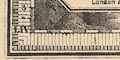
| piano key border |
The map has a piano key border.
|
|
|
|
||
|
title cartouche
plain cartouche |
Printed lower left in a plain octagonal cartouche:-
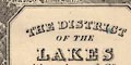
THE DISTRICT OF THE LAKES WARD, LOCK & Co. PUBLISHERS. London & New York. |
|
|
|
||
|
orientation
north point magnetic deviation |
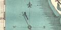
Printed left below centre is a north point; N-S line, E-W cross line, North marked by a fleur de lys, East and West labelled by letter. A line labelled:- Magnetic Needle shows the magnetic deviation at about 26d W, correct in the early 19th century; the deviation in 1818 was 24.64d W, in 1892 about 17.52d W. |
|
|
|
||
|
scale line
scale |
Printed lower middle is a scale of:-
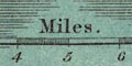
Miles chequered and labelled in miles. The 10 miles = 62.9 mm gives a scale 1 to 255858. The map scale is about:- 1 to 260000 4 miles to 1 inch |
|
|
|
||
| lat and long scales |
In the map borders there are scales of latitude and longitude for a trapezoidal projection; chequered in minutes, labelled at 10 minute intervals. The degrees are labelled in roman uppercase numerals; III for 3d W, and LIV for 54d N, though the latter is not a scale marking but just a hint to the reader. The map includes from 2d 40m to 3d 8m W, from 54d 2m to 54d 47m N; ; the Lakes cutting off Cumberland north of Sebergham, and Cumberland and Westmorland east of Shap. |
|
|
|
||
|
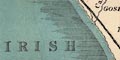
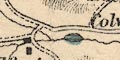
sea area
sea tinted |
The sea area is colour printed blue. A couple of sea
areas are labelled:-
THE IRISH SEA MORECAMBE BAY |
|
|
|
||
|
coast line
coast shaded sandbanks headlands harbours lighthouses |
The coast line is emphasised by two layers of shading into the offing from the edge of the foreshore shallows. The foreshore area is lightly dotted, and some areas are labelled, eg:- Lancaster Sands Cartmel Wharf Duddon Sands A few rocks are marked by crosses (+) off the Isle of Walney. A couple of headlands are labelled:- Heads [St Bees] Humphrey Head Harbours are not noticed but the channel into Barrow is clearly drawn, and there is a railway spur down to the coast there. The harbour moles at Whitehaven can be seen, if you look closely. 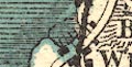
On St Bees Head is a tower labelled:- 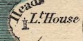
Lt. House |
|
|
|
||
|
rivers
bridges |
Rivers are drawn by a wiggly line tapering inland. Some rivers are labelled, eg:- Duddon River River Kent Mint R. In at least one instance, River Eden, where there is uncertainty, the direction of the stream is shown by an arrow. Bridges are implied where a road crosses and interrupts a stream. There are some bridge names, which might be settlement or bridge names, eg:- Penny Bridge Newby Bridge Pooley Bridge Some rivers or their estuaries are crossed by railways. Waterfalls might be marked by chevrons across the stream as at Lodore, and perhaps labelled, as at:- 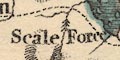
Scale Force |
|
|
|
||
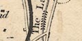
| lakes |
Lakes are drawn in outline with the shore line shaded, some lakes have a blue tint, some islands are drawn, some lakes are named:- BASSENTHWAITE Blea Tarn [Langdales] Blelham Tarn Brother Water Burnmoor Tarn CONISTON Crummock DERWENT Devoke Water Elter Water Esthwaite water Floutern Hawes Water LOWESWATER Over water Thirlmere ULLS WATER WINDER MERE Other lakes and tarns can be recognised, eg:- Angle Tarn, Borrowdale Angle Tarn, Martindale Beacon Tarn Bigland Tarn Blea Tarn, Borrowdale Blea Tarn, Eskdale Blea Water Bleaberry Tarn Blind Tarn Bowscale Tarn Buttermere Codale Tarn Easedale tarn Eel Tarn Ennerdale Water Goat Water Grasmere Greendale Tarn Grisedale Tarn Hayes Water Helton Tarn Keppelcove Tarn Levers Water Little Tarn Little Langdale Tarn Loughrigg Tarn Low Tarn Low Water Mockerkin Tarn Out Dubs Tarn Red Tarn Rydal Water Scales Tarn Scoat Tarn Seathwaite Tarn Skeggles Water Small Water Sprinkling Tarn Stony Tarn Styhead Tarn Tarns, The Wast Water Watendleth Tarn [blue splodge by Revelin, a mistake] |
|
|
|
||
|
relief
hill hachuring |
Relief is indicated by hill hachuring. The varying
boldness hints at greater hilliness in some areas. Some
mountains and hills are named, eg:-
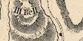
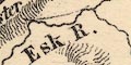
Ill Bell HELVELLYN Potter Fell Carrock A number of valleys are named, eg:- LONG SLEDDALE ESK DALE Dunnerdale And some passes are named, eg:- 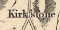
Kirkstone Gate Scarth Stake |
|
|
|
||
|
woods
parks |
A little woodland is indicated by tree symbols, for example at Lowther, and more obviously marking the park at Greystoke. 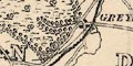
There is no label around:- Gowbarrow Parks |
|
|
|
||
| county |
A county boundary might be drawn by a fine dotted line, but is not continued along other features marking the bounds. County areas are labelled, eg:- WESTMORLAND |
|
|
|
||
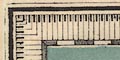
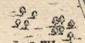
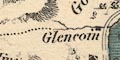
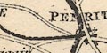
| settlements |
Settlements are marked by blocks or groups of blocks,
perhaps a cross for a church, differentiated by style of
labelling.
|
|
| towns |
blocks, and perhaps a cross; labelled in upright block
caps, eg:-
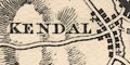
KENDAL AMBLESIDE SHAP |
|
| villages |
block or block and/or a cross; labelled in italic block
caps, eg:-
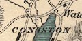
CONISTON GOSFORTH LOWICK |
|
| hamlets |
block and maybe a cross for a chapel; labelled in italic
lowercase text, eg:-
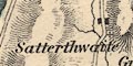
Satterthwaite Lazonby Notice the block labelled:- Scrogs at Loughrigg. This is a single farm house, and was the birthplace of Jonathan Otley who first drew this map. |
|
|
|
||
|
roads
sands roads |
A network of roads is drawn by double lines. More important roads are wider and might have one bold line. Dotted lines indicate either an unfenced road, or poorer quality track. Sands roads are shown by a double dotted line: across Lancaster Sands, from Hest Bank to Kents Bank; across Ulverston Sands, from near Holker to Canal Foot, Ulverston; and across Duddon Sands, from Ireleth towards Millom. |
|
|
|
||
| canals |
Canals are drawn by a double line. The two canals in the
area of the map are both shown.
|
|
| Lancaster Canal |
from the south through Lancaster, Lancashire; to Kendal,
Westmorland; notice the locks at Tewitfield. Labelled:-
The Lancaster Canal |
|
| Ulverston Canal |
from Ulverston to the coast, labelled:-
Canal |
|
|
|
||
| railways |
Railways are drawn by a bold black line which appears to have been drawn over a line with cross ties, perhaps someone changed their mind? A station might be shown by a circle. Some railways are labelled, eg:- Lancaster and Carlisle railway Furness railway M & Carlisle Railway |
|
|
|
||
| miscellaneous | ||
|
|
||
| inns |
Some inns are labelled, eg:-
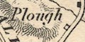
Plough [on Kendal to Shap road, Selside] Wheatsheaf [W of Bassenthwaite] It is not clear whether Huck's is an inn or just a house. |
|
|
|
||
|
antiquities
stone circles |
A 'circle' of dots by Keswick, Castlerigg Stone Circle,
is labelled:-
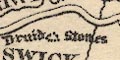
Druid Stones |
|
|
|
||
|
mines
black lead mines lead mines |
At Seathwaite there is:-
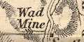
Wad Mine and up Glenridding:- Ld. Mine |
|
|
|
||
| religious houses |
A dot labelled:-
Abbey is Shap Abbey, and the same label marks an abbey symbol for Calder Abbey. 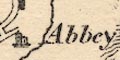
|
|
|
|
||
| castles |
An unlabelled castle symbol is used to mark Brougham
Castle. The symbol is labelled at:-
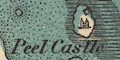
Peel Castle |
|
|
|
||
| stones |
The:-
Bowder Stone is labelled, and marked by a block. |
|
Lakes Guides menu.