 Ramble 1845

|

|
|

|
back to object record | |
| Map Features | ||
|
|
||
| title |
Printed lower right on the map is:-
WESTMORELAND |
|
|
|
||
| vignettes |
There are vignettes framing the map on the page. These
are labelled:-
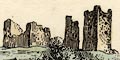
Brough Castle Stock-gill Force Slate Quarry Ullswater Lake 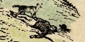
Notice that there is a small scene below Stockghyll Force which is a separate scene, unlabelled. It could be a picture of Charles Gough lying dead on the fell with his dog howling beside him. |
|
|
|
||
|
orientation
north point up is N |
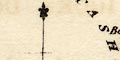
Printed lower left on the map is a north point; N-S line, E-W cross line, North marked by a fleur de lys. the map is printed with North at the top of the sheet. |
|
|
|
||
|
scale line
scale |
Printed lower left on the map is a:-
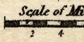
Scale of Miles chequered in miles, labelled every 2 miles. The 8 miles = 14.6 mm give a scale 1 to 881832 from scale line assuming a statute mile. The map scale is about:- 1 to 880000 14 miles to 1 inch |
|
|
|
||
| lat and long scales |
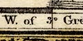
Printed in the map borders are scales of latitude and longitude for a rectangular projection; chequered and labelled at 10 minute intervals of longitude, of 5 minute intervals of latitude. The bottom longitude scale is labelled:- W of Greenh. Reading from the longitude scales the longitude, Kendal = 2d 47m W Kendal is 2d 44.8m W which is in rough, but not exact, agreement. |
|
|
|
||
|
sea area
sea shaded |
It is difficult to judge from the tiny area of sea shown
in the Kent Estuary, but the sea area seems to be
shaded.
|
|
|
|
||
|
coast line
coast shaded |
The tiny length of coast in the Kent Estuary is shaded for emphasis. |
|
|
|
||
|
rivers
bridges |
Rivers are drawn by a wiggly line tapering upstream,
where you can find them on this tiny map. None are labelled
except the:-
Ken River Bridges are not noticed, but see:- Bowland Br. labelling the settlement, and its small but significant boundary bridge. |
|
|
|
||
| lakes |
Lakes are drawn in outline, shaded. Only one lake is labelled:- Elter Water Other lakes might be recognized, eg:- Brothers Water (perhaps) Grasmere lake Rydal Water Ullswater Windermere lake |
|
|
|
||
| parks |
Parks are drawn by an outline of fence palings, the interior pecked. |
|
|
|
||
| county |
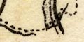
The county boundary is a dotted line, sometimes continued besides a boundary feature, sometimes not. Adjacent counties are labelled, eg:- CUMBERLAND Little is included outwith the county except Penrith, and Sedbergh on the road from Kirkby Lonsdale to Kirkby Stephen. |
|
|
|
||
| wards |
There are dotted lines dividing the county, presumably into its four wards. |
|
|
|
||
| settlements |
Settlements are marked by a block or two, differentiated
by style of labelling.
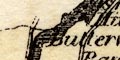
The choice of settlements to include on the tiny map is surprising, some very small settlements are included. The choice is not necessarily guided by what space is available between other features; thus, on the orad north of Kendal a single farm house called Hollow Gate is shown, and Oddendale which is a tiny hamlet is shown, but the village of Shap is missing tough it is represented by Brackenber. On the orad NW of Ambleside there is no Grasmere; and so on. Not all these choices can be explained by the change os size and importance of places between the 1810s and now. |
|
| towns |
block or blocks; labelled in upright lowercase text,
eg:-
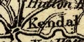
Kendal Kirkby Stephen Except:- APPLEBY in upright block caps, as it is the de jure county town. Towns listed, see:- |
|
|
villages
hamlets |
block; labelled in italic lowercase text, eg:-
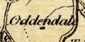
Oddendale |
|
|
|
||
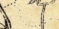
| roads |
A network of roads is drawn by double lines; some narrower, some broader with light bold lines, perhaps indicating turnpikes. |
|
Lakes Guides menu.