 Pratt 1905

|

|
|

|
back to object record | |
| NOTES from PRATT'S ROAD ATLAS of ENGLAND AND WALES, 1905 | ||
|
These notes are made from a road book, Pratt's Road Atlas of
England and Wales, road maps scale 6 miles to 1 inch, by
George Philip and Son, 32 Fleet Street, London, 1905,
published by Anglo-American Oil Co, 36-38 Queen Anne's Gate,
Westminster, London, 1915. The road book studied is in the
Map Collection of Hampshire CC Museums Service, item
HMCMS:FA2001.138.
|
||
|
The road maps are colour printed. The road book size is: wxh
= 13x22cm. These notes are strongly biased towards a local
interest.
|
||
| Cover and Title Page | ||
|
The cover is printed in black and gold on green:-
|
||
|
PRATT'S PERFECTION MOTOR SPIRIT ... PRATT'S ROAD ATLAS OF
ENGLAND AND WALES 6/- NET ANGLO-AMERICAN OIL CO., LTD.
|
||
|
and carries coats of arms indicating 'royal appointment' to
HM The King and HM Queen Alexandra.
|
||
|
The title page is printed in red and black on white:
|
||
|
PURVEYORS OF MOTOR SPIRIT TO H.M. THE KING. H.M. QUEEN
ALEXANDRA. PRATT'S ROAD ATLAS OF ENGLAND AND WALES FOR
MOTORISTS
|
||
|
COPYRIGHTED 1905 Published by ANGLO-AMERICAN OIL CO., LTD.,
36-38 QUEEN ANNE'S GATE, WESTMINSTER, LONDON, S.W. Engraved
and Printed by George Philip & Son, Ltd., 32 Fleet Street,
London E.C. REVISED EDITION, 1915.
|
||
| Lighting Up Times | ||
|
Before the title page there is a:-
|
||
|
PERPETUAL LIGHTING-UP TABLE
|
||
|
With lighting up time in hours and minutes tabulated in 12
rows, for each month, in 6 columns, for the 5th, 10th, 15th,
20th, 25th and 30th day. A note at the foot states:-
|
||
|
The above figures are for London and District; in other
parts of the country the times vary to the extent of a few
minutes. The figures in italics for the months from April to
September inclusive represent 'Summer Time'.
|
||
|
I think someone from the north of England might suggest that
lighting up time is more than a few minutes different?
|
||
| General Maps | ||
|
Before the series of road maps there are two general maps.
The first is a Railway Map of the British Isles at about 80
miles to 1 inch, showing principal and some minor routes.
The second is an index map of England and Wales showing the
page numbers for the 70 road map.
|
||
| ROAD MAP FEATURES | ||
|
|
||
| table of symbols |
An explanation for the series of road maps is given on a
preface page:-
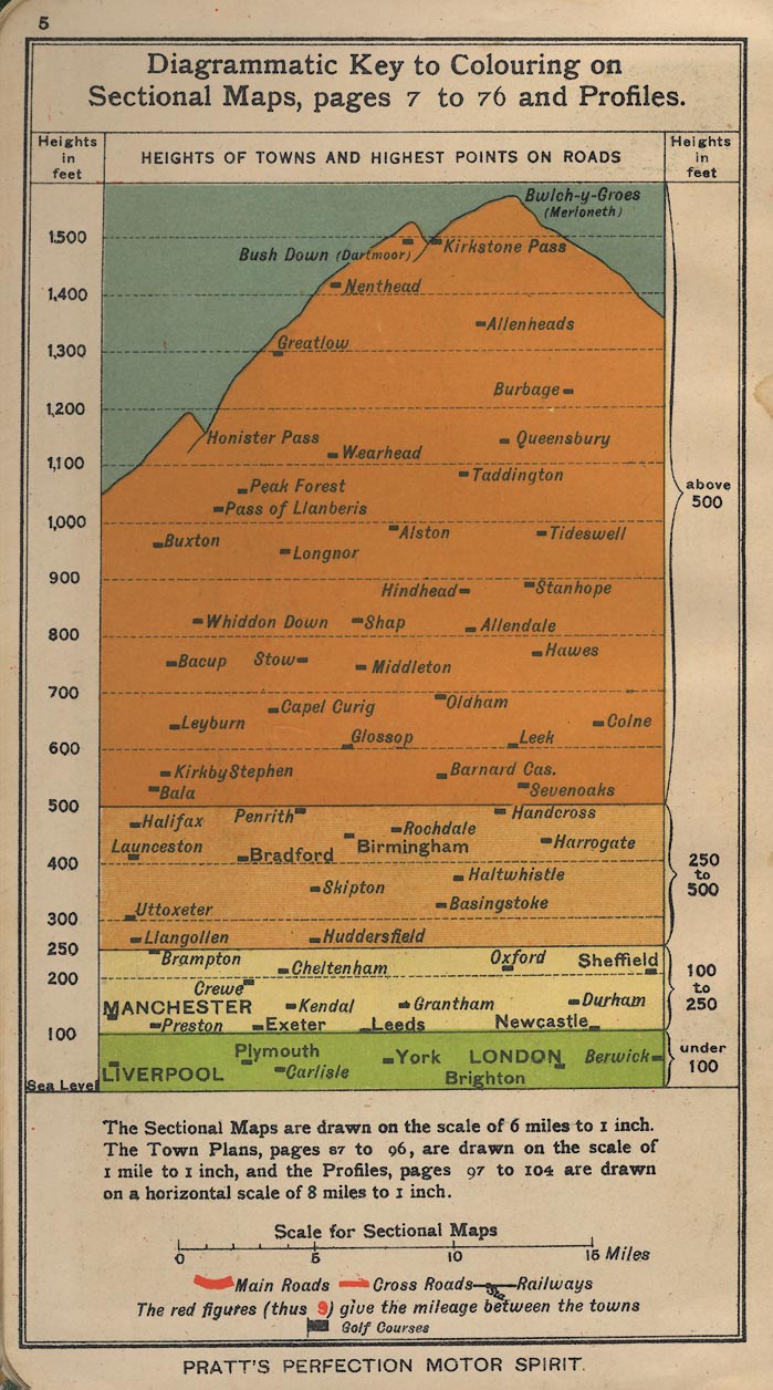
The dominant element of this is the:- Diagrammatic Key to Colouring on Sectional Maps, pages 7 to 76, and Profiles. Layer colouring is displayed as a mountain diagram, with a selection of places at their proper heights. The only Hampshire place is Basingstoke at about 325 feet. Map scales are declared:- The Sectional Maps are drawn to a scale of 6 miles to 1 inch. The town plans, pages 87 to 96 are drawn on the scale 1 mile to 1 inch, and the Profiles, pages 97 to 104 are drawn on a horizontal scale of 8 miles to 1 inch. Below is a scale line:- Scale for Sectional Maps and some map symbols:- [bold red line] Main Roads [red line] Cross Roads [black line] Railways The red figures (thus 9) give the mileage between the towns [square black flag] Golf Courses |
|
|
|
||
|
orientation
up is N |
The maps are printed with North at the top of each
sheet,as defined by the label text. Some sheets are printed
in 'landscape' and some in 'portrait' on the sheet.
|
|
|
|
||
| piano key border |
All the map have a piano key border around the open spread of two pages, which, printed separately, are designed as one map unit. The page numbers for adjoining sheets are printed in a circle in the borders. For example, most of Hampshire is on pp.11-12, two landscape pieces. The adjoining sheets are 9 to the east, 29, 20, 31 to the north, 13,14 to the west. Sea is to the south. |
|
|
|
||
|
scale line
scale |
A scale line is printed on the table of symbols page
preceding the road map pages, a:-
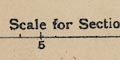
Scale for Sectional Maps marked in miles to 5 then at 5 mile intervals. The 15 miles = 63.5 mm gives a scale 1 to 380160. The road map scale is about:- 1 to 380000 6 miles to 1 inch |
|
|
|
||
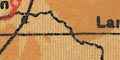
| lat and long grid |
Printed across each map is a latitude and longitude grid,
a graticule, at 20 minute intervals. Parallels and meridians
are labelled, eg:-
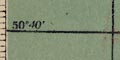
50 [degrees] 40 [minutes] 1 [degree] 20 [minutes] Reading as accurately as possible from the map longitude, Winchester = 1d 18.6m W which accords with a prime meridian at Greenwich; Winchester is usually taken as being 1d 18.4m W. |
|
|
|
||
|
sea area
sea tinted coast line harbours |
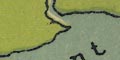
The sea area is printed blue, with some sea areas labelled, eg:- The Solent The coast line is not emphasised. Harbours are clearly recognisable, but not labelled. |
|
|
|
||
| rivers |
Above their estuaries, which are printed blue with the sea, rivers are drawn by a wiggly line tapering upstream. Some rivers are labelled, eg:- Test Itchen |
|
|
|
||
|
relief
layer colouring |
Relief is shown by layer colouring, printed without contour lines at the edges. The layers do not have equal vertical intervals. The table of symbols on a preface page explains:- Heights in feet under 100 [green] 100 to 250 [yellow] 250 to 500 [pale orange] above 500 [orange] The bold colours give the road maps a jolly appearance. Hills, downs, etc are generally not labelled. |
|
|
|
||
| forests |
Woodland is not generally noticed, but the:-
NEW FOREST area is labelled. |
|
|
|
||
| county |
County areas are not noticed on the road maps.
|
|
|
|
||
| settlements |
Settlements are marked by a circle or circles,
differentiated also by style of labelling. Only places on
routes are noticed.
|
|
|
city
town |
double circle; labelled in upright sans serif block caps.
eg:-
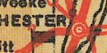
WINCHESTER WHITCHURCH Larger towns might be labelled in a slightly larger, serifed, block caps; in Hampshire:- SOUTHAMPTON PORTSMOUTH |
|
|
town
village hamlet |
circle; labelled in upright lowercase text, eg:-
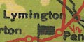
Alton Middle Wallop |
|
|
|
||
|
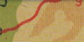
roads
road distances gradient diagrams |
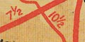
The network of roads is drawn by solid red lines, broad and narrow for main road and cross roads (a surprisingly old fashioned term?). Distances between towns are marked beside roads by red figures. You have to be careful how distances are understood, from which place to which? The pages after the road maps have gradient diagrams, road profiles, of a number of the main routes. The horizontal scale is about 8 miles to 1 inch; the base line marked and labelled at 5 mile intervals. The vertical scale is about 1100 feet to 1 inch; there are horizontal rules at 100, 250 and 500 feet, and the 'land' below the road line is layer coloured. Various places, settlements on hill tops, are labelled along the route. Each road profile is titled. 
Page 105 illustrates types of four road sign:- 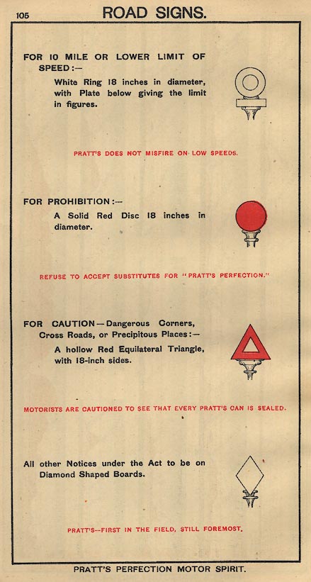
White ring; for a 10 mile per hour speed limit, or less. Red disk; prohibition. Red triangle; caution. White diamond for other 'Notices under the Act'. These signs are the first official road signs, defined by government legislation, the Motor Car Act 1903. There was a general speed limit of 20 miles an hour in 1903, so the lower speed restriction was all that was needed. Page 106 gives a table giving the speed in miles per hour against the time for 1 mile. The times are in minutes and seconds from 1 min. 0 sec. in steps of 1 second, to 6 min. 0 sec, a range of speeds from 60 mph to 10 mph. This is particularly useful if there was still a general speed limit of 20 miles per hour! |
|
|
|
||
| railways |
Railways are drawn by a bold black line, stations marked
by a circular or rectangular dot. Stations not labelled by a
settlement name are labelled in italic lowercase text,
eg:-
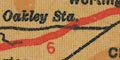
Oakley Sta. |
|
|
|
||
| miscellaneous | ||
|
|
||
| golf courses |
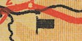
Only one miscellaneous feature is regularly marked, golf courses, by a small black rectangular flag on a low post. |
|
Lakes Guides menu.