 Perrot 1823

|

|
|

|
back to object record | |
| MAP FEATURES | ||
|
|
||
|
title
map maker |
Printed in a plain cartouche, lower centre:-
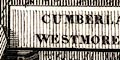
CUMBERLAND / WESTMORELAND Printed bottom left and right A. M. Perrot 1823 / Me. Migneret Sc. |
|
|
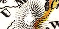
The map is hung from a map pole, surrounded by ?pertinent
items, a roof slate, oak leaves, mirror, wheat, a stocking,
horse harness, and an ?eagle which looks rather like a
vulture.
|
||
|
|
||
|
orientation
up is N |
The map is printed with North at the top of the
sheet.
|
|
|
|
||
| scale |
There is no indicator of scale. A crude estimate is a map
scale is about:-
1 to 2400000 38 miles to 1 inch |
|
|
|
||
| sea area |
The sea area is covered with from lines extending from
the coast. Two areas are labelled:-
G Solway B. de Morecambe |
|
|
|
||
|
coast line
coast form lines |
The coast line is emphasized by form lines. No foreshore is marked, but notice the label:- R. Duddon Sand (?) |
|
|
|
||
| rivers |
Rivers are drawn by a wiggly line tapering upstream. None are labelled, though most can be recognized; Eden, Lune, Kent, Derwent, etc. |
|
|
|
||
| lakes |
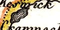
Lakes are drawn in rough outline with form lines. None are labelled, except that a settlement is labelled:- Crammock The following lakes can be recognized, but uncertainly:- Bassenthwaite Lake Coniston Water Derwent Water (?) Grasmere lake / Rydal Water Windermere lake |
|
|
|
||
|
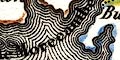
relief
hill hachuring |
Relief is suggested by hill hachuring. There are hills toward Northumberland, the Pennines. Off to the west is high ground in some part of The Lakes area. |
|
|
|
||
| county |
County boundaries are a fine dotted line. There is a tint along the inside of each county; Westmorland yellow, Cumberland red, Yorkshire blue, Northumberland blue, Durham pink, Dumfriesshire yellow. Lancashire seems to have been swallowed into Cumberland and Yorkshire. The county areas are labelled:- WESTMORELAND CUMBERLAND |
|
|
|
||
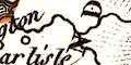
| settlements |
Settlements are marked by a circle, most are labelled in
the same style. On this tiny map only a few places are
shown.
|
|
| cities |
circle; labelled in italic lowercase text:-
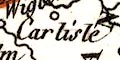
Carlisle |
|
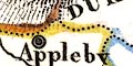
| towns |
circle; labelled in italic lowercase text, eg:-
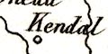
Kendal Penrith The de jure county town of Westmorland has a double circle and is labelled in upright lowercase text: 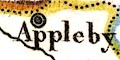
Appleby but Carlisle is not differentiated from other towns. |
|
Lakes Guides menu.