 Moule 1836

|

|
|

|
back to object record | |
| MAP FEATURES | ||
|
|
||
| picture frame border |
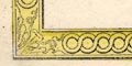
The map border is decorative, an unlikely style of picture frame border. |
|
|
|
||
| title cartouche |
Printed at the top in an early 19th century version of a
strapwork cartouche is:-
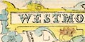
WESTMORELAND. |
|
|
|
||
| coat of arms |
There are four coats of arms on the map; approximate
blazons are given below, the colours are unreliable,
sometimes incomplete.
Printed upper right is the coat of arms of Lord Lonsdale, the Lowther Family:- 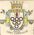
argent six annulets sable 3,2,1, charged a canton central argent a hand gules Printed lower right with the vignette of Appleby Castle, not completely coloured:- 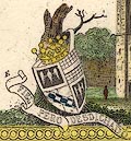
quarterly 1 and 2 sable an eagle displayed argent a bordure argent? 3 chequey or and azure a bend gules? 4 ? the 3rd quarter is the Clifford Family. And a motto:- FIEL PERO DESDICHADO Printed left below centre, the seal:- 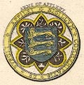
ARMS OF APPLEBY and caption:- APPILBI SIGILLUM / COMMUNITATIS DE BURGII azure three lions passant regardant crowned or Printed lower left, the 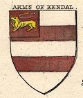
ARMS OF KENDAL barry argent and gules 5 in a canton gules a lion passant or which is not the arms of Kendal today. I do not know the arms of the Parr Family. |
|
|
|
||
| vignettes |
The map has two vignettes; upper left:-
BROUGHAM HALL lower right:- 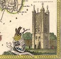
KEEP OF APPLEBY CASTLE |
|
|
|
||
|
orientation
up is N |
The map is printed with North at the top of the
sheet.
|
|
|
|
||
|
scale line
scale |
Printed lower left is a:-
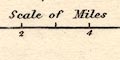
Scale of Miles divided at miles, labelled 1,2,4,6. The 6 miles = 30.3 mm gives a scale 1 to 318682 on the reasonable assumption of a statute mile. The map scale is about:- 1 to 320000 5 miles to 1 inch |
|
|
|
||
|
coast line
coast form lines |
The coast line in the Kent Estuary is emphasised by form lines, tinted blue. |
|
|
|
||
|
rivers
bridges |
Rivers are drawn by wiggly line tapering at the head.
Some rivers are labelled, eg:-
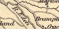
Brathy R. Crowdundle Beck River Ken R. Eamont Bridges are implied where a road crosses and interrupts a stream. Most are not labelled, but see:- 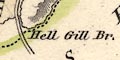
Hell Gill Br. |
|
|
|
||
| lakes |
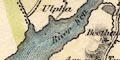
Lakes are drawn in outline with form lines, tinted blue.
Some are labelled:-
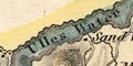
Ulles Water Winander Mere Rydal Wr. Grasmere L Hawes Wr. Reservoir [Killington] Kentmere tarn [labelled, not drawn] Elter Water a few others can be recognised:- Great Langdale Tarn Easedale Tarn [?] Brothers Water Hayes Water Sunbiggin Tarn [?] Dogber Tarn [???] |
|
|
|
||
|
relief
hill hachuring |
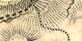
Relief is indicated by hill hachuring, tinted brown.
Hills are grouped to suggest the central heights of the Lake
District, the Shap Fells, Pennines, etc. But it is not very
successful. Hills might be labelled, eg:-
Shap Fells Whitbarrow Scar Helvellin Yew Craggs A valley might be labelled, eg:- Long Sleddale Langdale Borrow Dale |
|
|
|
||
| beacons |
One hill is labelled:-
Barbon Beacon |
|
|
|
||
| forests |
No woodland is indicated, but a forest might be labelled,
eg:-
Stainmoor Forest Milbourn Forest |
|
|
|
||
| parks |
Parks are drawn in outline with fence palings, the
interior dotted and perhaps tinted green. A park might be
labelled, or named by a house, eg:-
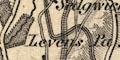
Levens Pa. Sizerb Ha. |
|
|
|
||
| county |
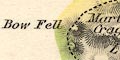
The county boundary is a dashed line. Adjacent counties are not divided but are tinted along their part of the boundary; Cumberland yellow, Lancashire green or red, Yorkshire green or red, Durham green. Because the colourist is not guided by boundaries between these counties the colouring has gone wrong; for example Lancashire's green extends round to Bow fell instead of changing to Cumberland's yellow at the Three Shire Stones. Colours are not one per county. Adjacent counties are labelled, eg:- CUMBERLAND LANCASHIRE |
|
|
|
||
| wards |
Boundaries of the wards, roughly the equivalent of hundreds, are a fine dotted line. The ward areas are labelled by number keying to a table of wards printed upper right:- REFERENCE to the WARDS East ward ... 1 West Ward ... 2 Kendal ... 3 Lonsdale ... 4 |
|
|
|
||
|
settlements
electoral data |
Settlements are marked by a block or blocks and/or a
cross for a church, differentiated by style of
labelling.
|
|
| towns |
group of blocks; labelled in upright lowercase text,
eg:-
Kendal Orton but in upright block caps:- APPLEBY the de jure county town. Kendal has a single asterisk indicating it sends one member to Parliament, and is enclosed by a dot dash boundary for the borough area. This map is made after the Reform Act 1832. Printed upper right, below the table of hundreds, is:- The County returns 2 members. |
|
|
villages
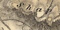
hamlets |
block or blocks and/or a cross; labelled in italic
lowercase text, eg:-
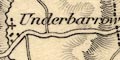
Underbarrow Shap Stockdale Askham The cross is not a reliable indicator of a church of a village. The style of labelling is used for other map features. |
|
| castles |
Castles have a special symbol, a square with lines
radiating from each corner, for example:-
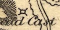
Lamerstead Cast Castle [at kendal] |
|
|
|
||
| roads |
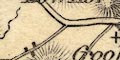
A network of roads are drawn by double line, in two widths. The broader roads have light bold lines, which is sometimes used to denote turnpikes. One road is labelled at the county boundary, with its destination:- from Keswick Sedbergh, Yorkshire and the road passing through it from one part of Westmorland to another, is shown on the map. |
|
|
|
||
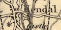
| canals |
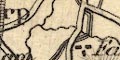
A canal is drawn by a triple line, light bold light. |
|
| Lancaster Canal |
from the south, into Kendal.
|
|
|
|
||
| railways |
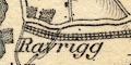
Railways are drawn by a triple line with cross hatching. The way they are engraved makes it obvious they are additions to the map, the lines were not open till 1846, although they were authorised, the routes known, a year or two earlier. The map is a later edition, about 1846? Two lines can be recognised:- |
|
| Lancaster and Carlisle Railway |
from the south, labelled at the county
boundary:-
To Lancaster through stations at Milthorp, Oxenholme, Low Gill, Tebay, Shap, Clifton, and north, labelled:- from Carlisle |
|
| Kendal and Windermere Railway |
from a junction at Oxenholme, through a
station at Staveley, to an unmarked end at Rayrigg.
No station at Kendal; no village at Windermere! |
|
|
|
||
| miscellaneous | ||
|
|
||
| stones |
There is a label:-
3 Shire Stones where the adjacent counties of Lancashire and Cumberland should meet; the tints for them are wrong. Labelled where the County Stone might be is:- Lady Pillar |
|
|
|
||
| monuments |
A label near the county boundary ESE of Kirkby Stephen
is:-
Nine Standards |
|
|
|
||
|
antiquities
roman sites roman forts |
Labelled on Stainmoor Fell is:-
Roman Camp |
|
Lakes Guides menu.