 Marshall 1808 map

|

|
|

|
back to object record | |
| MAP FEATURES | ||
|
|
||
|
title
engraver publisher |
Printed upper right:-
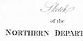
Sketch of the NORTHERN DEPARTMENT, of ENGLAND. Printed bottom centre and right:- Publish'd by Longman, Hurst, Rees & Orme, Paternoster Row. To be hung in with a Guard, before Page 1 / Mutlow sc Russell Ct. |
|
|
|
||
|
orientation
up is N |
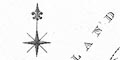
Printed upper left is a compass rose; star points for cardinal directions, lines for half cardinal directions, North marked with a fleur de lys spear point. The map is printed with North at the top of the sheet. |
|
|
|
||
|
sea area
sea plain |
Sea areas are plain, and might be labelled, eg:-
THE IRISH SEA |
|
|
|
||
|
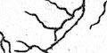
coast line
coast form lines |
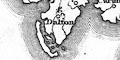
The coast line is emphasized by form lines. While headlands can be recognized, none is labelled. |
|
|
|
||
| rivers |
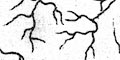
Rivers are drawn by a wiggly line tapering up stream. A few of the larger streams are labelled, eg:- Ken R. Loyne R. R. Derwent One river valley is noticed as one of the report's regions:- THE VALLEY OF APPLEBY ie the Eden Valley. |
|
|
|
||
| lakes |
Lakes are hardly noticed, they might be drawn in simple outline. None is labelled, but several might be recognized, eg:- Buttermere lake Codale Tarn Coniston Water Crummock Water Easedale Tarn Easthwaite Water Ennerdale Water Loweswater lake Wast Water Windermere lake |
|
|
|
||
| relief |
No relief is shown. The immediate impression of the
sketch map is that relief and rivers are not pertinent to
agriculture.
|
|
|
|
||
|
county
regions |
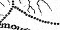
Counties are not directly noticed on the map, but their names are used in naming agricultural regions. The regions are bounded by dotted lines, some of which are missing; between the Eden Valley and Carlisle plain, between the central mountains and western Yorkshire moors. In Cumbria the regions are:- |
|
| THE MORELANDS OF NORTHUMBERLAND |
including the Spadeadam area of Cumberland.
|
|
| THE MORELANDS OF THE FIVE COUNTIES |
including the area NE of the Eden Valley from Brampton
eastward.
|
|
| THE DISTRICT OF CARLISLE |
including Longtown, Brampton, Carlisle, Wigton, etc. Not
clearly divided from the Valley of Appleby.
|
|
| THE VALLEY OF APPLEBY |
The Eden Valley up to Kirkby Stephen. Not clearly divided
from the District of Carlisle.
|
|
|
SEA COAST OF CUMBERLAND
c. |
Coastal area from the Wampool round to Ulverston,
including Cockermouth.
|
|
| THE MOUNTAINS OF CUMBERLAND |
including the central mountains of both Westmorland and
Cumberland.
|
|
| THE DISTRICT OF KENDAL |
including the Kent and Leven valleys, parts of the Lune
valley, etc. Not clearly divided from the West Yorkshire
moors.
|
|
| THE WESTERN MOORLANDS OF YORKSHIRE |
including the Howgills, Sedbergh, etc. Not clearly
divided from the Kendal region.
|
|
|
|
||
| settlements |
A few settlements are marked as reference points, marked
by a circle and (mostly) labelled.
|
|
| cities |
circle; labelled in upright block caps, eg:-
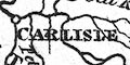
CARLISLE |
|
| towns |
circle; labelled in upright lowercase text, eg:-
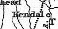
Penrith Kendal |
|
Lakes Guides menu.