 Hodgson 1828

|

|
|
|
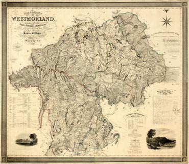
Map, hand coloured engraving, 4 sheets mounted together,
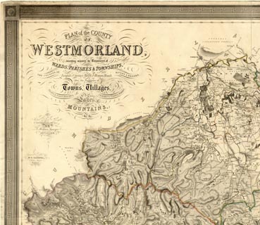
Plan of the County of Westmorland, scale about 1.25 inches
to 1 mile, by T Hodgson, engraved by W R Gardner, Harpur
Street, London, published by Thomas Hodgson, Lancaster, and
perhaps by C Smith, 172 Strand, London,1828.
There are vignette views - Appleby Castle from the SE drawn by J Henderson, Lowther Castle from the NW drawn by De Witt. |
||

|
Hodgson 1828 | |
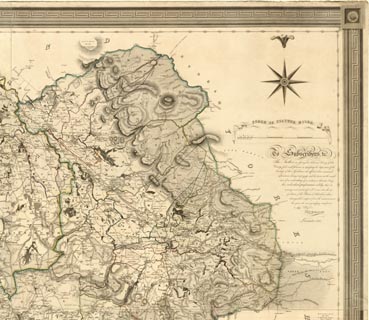
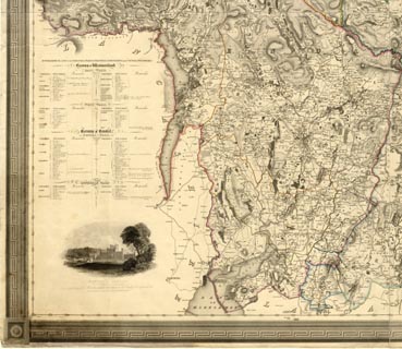
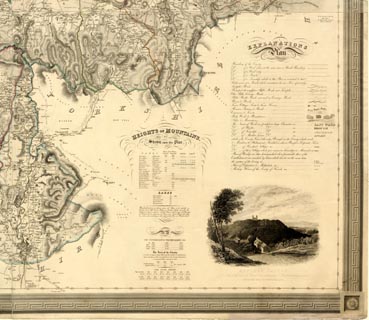
| map feature:- | slip case & sectioned for folding & mounted & folded (6x8) & dedication (sort of) & table of symbols & picture frame border (greek key design) & compass rose & up is N & scale line & lat and long scales & coast form lines & rivers & bridges & lakes & relief & hill hachuring & table of heights (HEIGHTS OF MOUNTAINS, Above Low Water - eg Helvellyn Patterdale 3055 Feet, Ordnce. Sur. 3070 Feet Barometer Latitude 54 31 43 Long. W 3 0 21) & woods & forests & parks & county & wards & parishes & settlements & roads & turnpike roads & road distances & descriptive text (lists of towns, parishes, wards, baronies - eg Barony of Kendal - KENDAL WARD - KENDAL PARISH - Long Sleddale Township; and depths of lakes, populations, areas, poor rates) & vignettes | |
| inscription:- |
printed upper left
PLAN of the COUNTY / OF / WESTMORLAND, / describing minutely the Boundaries of / WARDS, PARISHES, & TOWNSHIPS, / THE COURSES OF Turnpike, Carriage, Bridle, & Roman Roads, RIVERS & BROOKS, / also the Positions of / Towns, Villages, / SEATS & FARM HOUSES, COMMONS, PARKS, WOODS, / Lakes, / MOUNTAINS, / &c. &c.// FROM AN / Actual Personal Survey, / Taken during the Years 1823, 4 & 5. / BY / T. Hodgson, Surveyor, / LANCASTER. // Engraved & Printed by / W. R. GARDNER, / Harpur Street, London. |
|
| inscription:- |
printed almost a dedication
To Subscribers, &c. / The Author in issuing his elaborate Survey of this / County feels much pleasure in explaining his deep sense of the / Kindness of those Gentlemen who afforded him occasional / information during its progress; and he trusts, at the comple- / tion of an undertaking of so arduous a character, being / his individual performance solely, that its / accuracy and minuteness will ensure him the ap- / probabtion of his Patrons & Subscribers, whose / distiguished support from the commencement / has given the most gratifying satisfaction / to his Obliged / THOs. HODGSON. / Lancaster, 1828. |
|
| inscription:- |
printed bottom
PUBLISHED OCTR. 6TH. BY T. HODGSON. SURVEYOR, LANCASTER & SOLD BY C. SMITH, 172, STRAND, LONDON. |
|
| inscription:- |
printed caption to vignette
From the S.E. / APPLEBY CASTLE / The Seat of the Earl of Thanet, from a drawing by J. Henderson, engraved for HODGSON'S MAP OF WESTMORLAND. |
|
| inscription:- |
printed cation to vignette
From the N.W. / LOWTHER CASTLE, The Seat of the Earl of Lonsdale. From a drawing by De Witt presented to the Author by the Family, MAP OF WESTMORLAND.to be engraved for HODGSON'S A |
|
| inscription:- |
printed with scale line
SCALE OF STATUTE MILES. |
|
| scale line:- | 5+1 miles = 199.3 mm | |
| wxhxd, slip case:- | 19x28x2cm | |
| wxh, folded:- | 27x17.5cm | |
| wxh, sheet:- | 160x137cm (?) | |
| wxh, map, excluding gaps:- | 1572x1358mm (?) | |
| scale:- | 1 to 48000 ? (1 to 48450 from scale line, assuming ) | |