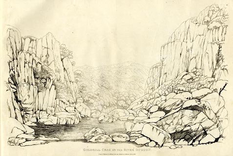
 Goldrill Crag on the River Duddon

|

|
|
|
item:- Armitt Library : A6641.49 image:- © see bottom of page |
click to enlarge |
|
|
Print, soft ground etching, Goldrill Crag on the River
Duddon, Ulpha, Cumberland, by William Green, Ambleside,
Westmorland, 1808.
Plate 49 in Sixty Studies from Nature, 1810. |
||
|
No. 49.
GOLD-RILL CRAG, ON THE RIVER DUDDON. The river Duddon divides Lancashire and Cumberland, from the county stones on Wrynose, to its junction with the Irish sea; consequently, the scene before us is in both counties. - This view is down the river; the left hand rock is in Lancashire, and Goldrill Crag, which is on the right, is in Cumberland. The Lancashire side of this river, from Broughton to Cockley Beck Bridge, which bridge is on the road from Ambleside to Wastdale, is chiefly the township of Seathwaite, a district deeply but charmingly entrenched among the mountains: Cockley Beck Bridge is four miles above Seathwaite chapel, and Goldrill Crag is half way between them. |
||
| source type:- | Green 1810 (plate 49) | |
| inscription:- |
printed top right
49 |
|
| inscription:- |
printed bottom
GOLDRILL CRAG ON THE RIVER DUDDON. / Drawn and Engraved by William Green, and Published at Ambleside, June 24, 1808. |
|
| inscription:- |
watermark:
J WHATMAN / 1811 |
|
| wxh, page:- | 74x52.5cm | |
| wxh, plate:- | 698x475mm (about) | |
| wxh, image:- | 67x44cm (about) | |