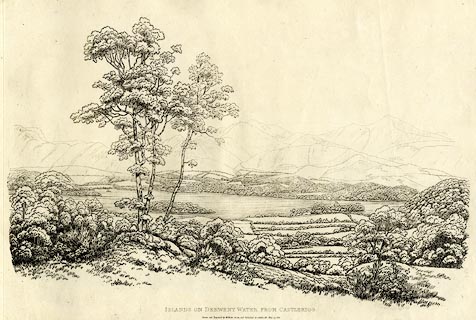
 Islands on Derwent Water from Castlerigg

|

|
|
|
item:- Armitt Library : A6641.31 image:- © see bottom of page |
click to enlarge |
|
|
Print, soft ground etching, Islands on Derwent Water from
Castlerigg, Keswick, Cumberland, by William Green,
Ambleside, Westmorland, 1810.
From near right to far - Derwent Isle, Lord's Island, St Herbert's Island? Plate 31 in Sixty Studies from Nature, 1810. |
||
|
No. 31.
THE ISLANDS ON DERWENT WATER. The site of the present scene is near that of the last, but looking towards the mountains of Newlands and Braithwaite, and this view comprehends the three large islands. Lord's Island is beyond the trees, and on the other side of the lake see Water-end bay, at the extremity of which stands that tasteful building erected by Lord William Gordon, for his occasional residence; all the lands bounding that side of the lake observed here belong to his lordship. - Vicars Island, late Pocklington's Island, now the property of Colonel Peché, from this place apparently in contact with the mainland, is on the right, and St. Herbert's on the left. The mountains Swinside, Barrow, and Grisdale, with its pike, are seen over Vicar's Island; and at the St. Herbert's end of this scene, the two Cat Bells, and beyond them Hindsgarth in Newlands - the centre is occupied by Causey Pike, and the more distant mountain Grasmire, which mountain is the eastern boundary of Crummock Water. |
||
| source type:- | Green 1810 (plate 31) | |
| inscription:- |
printed top right
31 |
|
| inscription:- |
printed bottom
ISLANDS ON DERWENT WATER FROM CASTLERIGG. / Drawn and Engraved by William Green, and Published at Ambleside, June 24, 1810. |
|
| inscription:- |
watermark:
J WHATMAN / 1813 |
|
| wxh, page:- | 74x52.5cm | |
| wxh, plate:- | 675x478mm (about) | |
| wxh, image:- | 66x42cm (about) | |