 Otley 1830s

|

|
|
|
item:- private collection (305) image:- © see bottom of page |
click to enlarge |
|
|
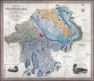
Geological map, 4 sheets, engraving, hand coloured to
show geology, Plan of the County of Westmorland, scale about
1 1/4 inches to 1 mile, surveyed 1823-25 by Thomas Hodgson,
engraved by W Gardner, Harpur Street, London, published by
Thomas Hodgson, Lancaster, Lancashire, 1828; geologically
coloured probably by Jonathan Otley, after 1835.
Fitted round the vignette lower left is a table of strata added in manuscript. Note the use of 'Silurian' which was not in use till 1835. Comparison of equally formal lettering on other maps by Jonathan Otley, in a private collection, makes it very likely that the geological colouring is by him. |
||

|
Otley 1830s | |
| map feature:- | decorative border & dedication & vignettes (Appleby Castle, Lowther Castle) & table of symbols & compass rose & up is N & scale line & coast form lines & rivers & lakes & relief & hill hachuring & spot heights (few) & woods & forests & parks & commons & county & wards & table of wards & parishes & settlements & roads & turnpike roads & sands roads & roman roads & canals & table of data (heights of mountains, heights of lakes, populations, poor rates, areas) & geology & table of strata | |
| inscription:- |
printed upper left, sheet A
PLAN of the COUNTY / OF / WESTMORLAND, / describing minutely the Boundaries of / WARDS, PARISHES & TOWNSHIPS, / THE COURSES OF RIVERS & BROOKS, / Turnpike, Carriage, Bridle, & Roman Roads, / also the positions of / Towns, Villages, / SEATS & FARM HOUSES, COMMONS, PARKS, WOODS, / Lakes, / MOUNTAINS, / &c. &c. |
|
| inscription:- |
printed upper left, sheet A
FROM AN / Actual Personal Survey / Taken during the Years 1823, 4 & 5. / BY / T. Hodgson, Surveyor, / LANCASTER. // Engraved & Printed by / W. R. GARDNER, / Harpur Street, / London. |
|
| inscription:- |
printed dedication
To Subscribers ... THOS. HODGSON, Lancaster, 1828. |
|
| inscription:- |
ms lower left
GEOLOGICAL Colours and Signs after PROFESSOR SEDGWICK. / [pale orange] New Red Sandstone / [pale orange with red spots] Conglomerate of Do. / [pale brown] Millstone Grit and Lower Beds of Coal &c. / ]pale blue] Alternations of Shale and Limestone. / [mid blue] Great Scar Limestone. / [brick red] Old Red Sandstone / [pale lilac] Upper Slate Series (Silurian System) / [dark blue] Band of Limestone of Coniston Water Head &c. / [pale green] Green Slate, alternating with Numerous Masses of Felspar Porphyry. / [purple] Skiddaw Slate. / [pale green with red spots] Trappean Rock in Mass. / [pale green with red streaks] Do. in Beds in Masses alternating with Slate. / [red] Granite table of strata |
|
| scale:- | 1 to 48000 ? | |