 CTC 1911

|

|
|
|
item:- JandMN (491_17) image:- © see bottom of page |
click to enlarge |
|
|
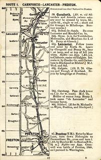
Strip road map, route 1, Carnforth Lancaster Preston,
part of Carlisle to Tarporley, scale about 5 miles to 1
inch, published by Thomas Nelson and Sons, London etc, 1911.
Page 17 of Cyclists' Touring Club British Road Book new series vol.6, edited by F B Sandford. Together with an itinerary and gradient diagram. |
||

|
CTC 1911 | |
| map feature:- | table of symbols (road book p.14) & north point & up is start & scale line (in gradient diagram) & relief (in gradient diagram) & rivers & county & settlements & roads & road distances & railways & descriptive text | |
| wxh, page:- | 11x16.5cm | |
| scale:- | 1 to 320000 ? | |