 CTC 1911

|

|
|
|
item:- JandMN (491_1) image:- © see bottom of page |
click to enlarge |
|
|
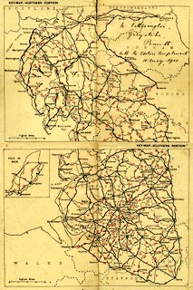
Road map, index map, northern and southern portions of
roads in North West England, scale about 13 miles to 1 inch,
published by Thomas Nelson and Sons, London etc, 1911.
Inside front and back covers Cyclists' Touring Club British Road Book new series vol.6, edited by F B Sandford. Black and white map overprinted with route numbers in red. |
||

|
CTC 1911 | |
| map feature:- | up is N & scale line & sea plain & coast line & rivers & lakes & county & settlements & roads | |
| inscription:- |
printed with scale line
English Miles |
|
| scale line:- | 20 miles = 38.7 mm | |
| wxh, page opening:- | 22x16.5 | |
| wxh, map (combined):- | 201x294mm | |
| scale:- | 1 to 830000 ? (1 to 831703 from scale line) | |