 AA 1933

|

|
|
|
item:- JandMN (472_10) image:- © see bottom of page |
click to enlarge |
|
|
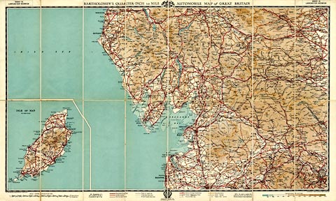
Road map, Bartholomew's Quarter Inch to Mile Motoring Map
of Great Britain, sheet 10, Lancaster - Keswick, scale about
4 miles to 1 inch, produced for the Automobile Association,
AA, by John Bartholomew and Son, Edinburgh, 1933.
|
||

|
AA 1933 | |
| map feature:- | card covers & index map & location map & sectioned for folding & mounted & folded (8x2) & table of symbols & up is N & scale line & sea tinted & coast line & foreshore sands & harbours & headlands & lighthouses & rivers & lakes & relief & layer colouring & spot heights & table of heights & county & settlements & roads & railways & canals | |
| inscription:- |
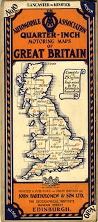
printed cover
No.10 LANCASTER - KESWICK NORTH / THE AUTOMOBILE [AA badge] ASSOCIATION / QUARTER - INCH / MOTORING MAPS / OF / GREAT BRITAIN / [index map] / [royal coat of arms] BY APPOINTMENT / PRINTED AND PUBLISHED IN GREAT BRITAIN BY / JOHN BARTHOLOMEW & SON LTD. / THE GEOGRAPHICAL INSTITUTE / DUNCAN STREET / EDINBURGH. SOUTH No.10 |
|
| inscription:- |
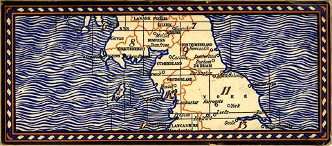
printed back cover
[location map] |
|
| inscription:- |
printed top left, centre, right
SHEET 10 LANCASTER-KESWICK / BARTHOLOMEW'S QUARTER INCH to MILE [royal coat of arms]AUTOMOBILE MAP of GREAT BRITAIN / SHEET 10 LANCASTER-KESWICK |
|
| inscription:- |
printed bottom centre
[AA badge] 19 33 / ROAD REVISED BY THE / AUTOMOBILE ASSOCIATION |
|
| inscription:- |
printed bottom left, right
THE EDINBURGH GREOGRAPHICAL INSTITUTE / COPYRIGHT - JOHN BARTHOLOMEW & SON, LTD. |
|
| inscription:- |
printed with sacle line
SCALE 1 : 253440 4 MILES TO AN INCH / ENGLISH MILES / ... |
|
| scale line:- | 20+1 miles = 134.7 mm (?) | |
| wxh, folded:- | 23x10cm | |
| wxh, sheet:- | 75.5x45cm | |
| wxh, map (including gaps):- | 722x413mm | |
| scale:- | 1 to 250000 ? (1 to 250900 from scale line) | |
|
||
|
||