 Cary 1801

|

|
|
|
item:- Armitt Library : 1959.189 image:- © see bottom of page |
click to enlarge |
|
|
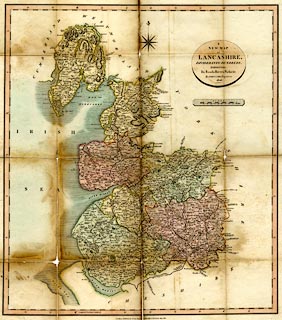
Map, hand coloured engraving, A New Map of Lancashire,
scale about 4 miles to 1 inch, by John Cary, 181 Strand,
London, 1806.
|
||

|
Cary 1801 | |
| map feature:- | oval cartouche & compass rose & up is N & scale line & lat and long scales & sea plain & coast shaded & harbours & rivers & lakes & relief & hill hachuring & woods & parks & county & settlements & roads & road distances & distances from London & canals | |
| inscription:- |
printed oval cartouche, upper right
A / NEW MAP / OF / LANCASHIRE, / DIVIDED INTO HUNDREDS, / EXHIBITING / Its Roads, Rivers, Parks &c. / By JOHN CARY, Engraver, / 1806. |
|
| inscription:- |
printed bottom
London; Published by J. Cary Engrave[ ] & Map seller No.181 Strand July 1. 1806. |
|
| inscription:- |
printed with scale line
SCALE. / Miles |
|
| scale line:- | 10 miles = 63.3 mm | |
| wxh, sheet:- | 58.5x72cm | |
| wxh, plate:- | 520x574mm (approx) | |
| wxh, map:- | 478x538mm (approx) | |
| scale:- | 1 to 250000 ? (1 to 254241 from scale line) | |