 Carlyle 1791

|

|
|
|
item:- Tullie House Museum : 1978.108.77.3 image:- © Tullie House Museum |
click to enlarge |
|
|
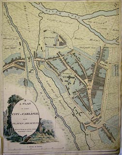
Map, watercolour, A Plan of the City of Carlisle and
Places Adjacent, Cumberland, by Robert Carlyle snr, 1791.
Included in an album of The Antiquities of the City of Carlisle. Street plan of Carlisle showing the city walls and gates prior to their demolition and showing the surrounding land beyond. The title of the plan is set in an oval bottom left and surrounded by a watercolour showing a man moving a roman altar, two men in the middle distance, a ruined church to the left and a distant view of Carlisle Cathedral far right. |
||

|
Carlyle 1791 | |
| inscription:- |
inscribed bottom left
A PLAN OF THE CITY OF CARLISLE AND PLACES ADJACENT DRAWN FROM AN ACTUAL SURVEY BY ROBERT CARLILE |
|
| wxh, sheet:- | 32x42cm | |