 Bacon 1870s

|

|
|
|
item:- private collection (284) image:- © see bottom of page |
click to enlarge |
|
|
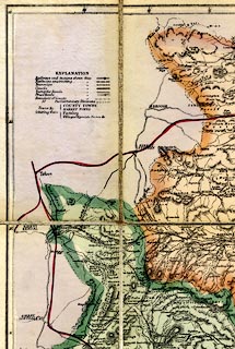
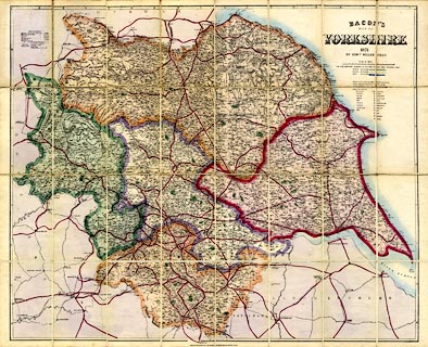
Map, hand coloured lithograph, Bacon's Map of Yorkshire,
scale about 3.5 miles to 1 inch, by Edward Weller, published
by G W Bacon and Co, 127 Strand, London, 1871
|
||

|
Bacon 1870s | |
| map feature:- | card cover & sectioned for folding & mounted & folded (8x4) & table of symbols (minimal) & up is N & scale line & lat and long scales & sea tinted & coast line & rivers & relief & hill hachuring & parks & county & settlements & roads & railways & electoral data | |
| inscription:- |
printed upper right
BACON'S / MAP OF / YORKSHIRE / 1871 / BY EDWD. WELLER F.R.G.S. |
|
| inscription:- |
printed bottom
LONDON, G. W. BACON & Co. 127, STRAND, 20 DOORS WEST OF SOMERSET HOUSE. |
|
| inscription:- |
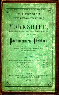
printed cover
BACON'S NEW SERIES OF COUNTY MAPS. / BACON'S / NEW LARGE-PRINT MAP / OF / YORKSHIRE, / REDUCED FROM THE ORDNANCE SURVEY / SHEWING THE NEW / Parliamentary Divisions. / Also all the Railways and Stations, and / every Town, Village, Hamlet, and / Gentleman's Seat. / PRICE / Coloured, on Roller, Varnished, Cloth Back 6s. 0d. / Coloured, with manogany Roller 9s. 6d. / Coloured, on Cloth, in Case 6s. 0d. / Coloured, Folded in Paper Boards 2s. 6d. // LONDON : / G. W. BACON & CO., Agents by Appointment for / the Ordnance Maps, 127, Strand. / 1870. black on green |
|
| inscription:- |
printed with scale line
Scales of Miles |
|
| scale line:- | 15 miles = 109.1 mm | |
| scale:- | 1 to 220000 ? (1 to 221266 from scale line) | |
| wxh, cover:- | 12.5x19.5cm | |
| wxh, sheet:- | 93.5x75cm | |
| wxh, map (with gaps):- | 878x722mm | |
|
||
|
||