 Jeffery 1775

|

|
|
|
item:- private collection (271_6) image:- © see bottom of page |
click to enlarge |
|
|
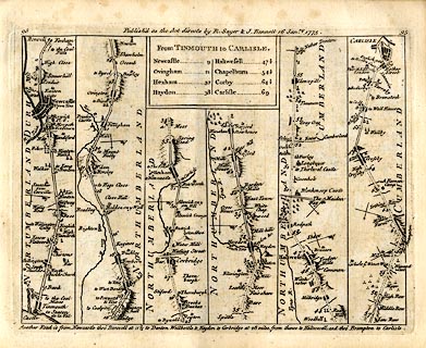
Strip map, road map, From Tinmouth to Carlisle, by Thomas
Jefferys, published by R Sayer and J Bennett, 53 Fleet
Street, London, 1775.
Plate 95 in Jefferys's Itinerary or Travellers Companion. |
||
| map type:- | Jeffery 1775 (pl.95/Roads) | |
| map feature:- | title cartouche & plain cartouche & north point & up is destination & rivers & relief & hillocks & county & settlements & roads & road distances & distances from start | |
| inscription:- |
printed plain cartouche, upper centre
From TINMOUTH to CARLISLE. / Newcastle 9 / Ovingham 21 / Hexham 32 / Haydon 38 / Haltwesell 47 1/2 / Chapelburn 54 1/2 / Corby 64 1/2 / Carlisle 69 |
|
| inscription:- |
printed top
95 / Publish'd as the Acts directs by R. Sayer & I. Bennett 16 Janry. 1775. / 95 |
|
| wxh, sheet:- | 22.5x18.5cm | |
| wxh, map:- | 195x147mm | |