 Jeffery 1775

|

|
|
|
item:- private collection (271_3) image:- © see bottom of page |
click to enlarge |
|
|
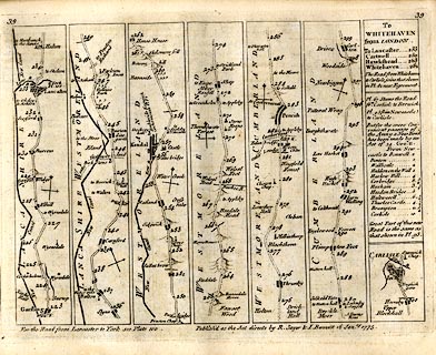
Strip map, road map, part of From London to Carlisle,
from Garstang through Lancaster, Lancashire; then
Burton-in-Kendal, Kendal, Shap, Westmorland; Penrith to
Carlisle; and an itinerary from Lancaster to Whitehaven, by
Thomas Jefferys, published by R Sayer and J Bennett, 53
Fleet Street, London, 1775.
Plate 39 in Jefferys's Itinerary or Travellers Companion. |
||
| map type:- | Jeffery 1775 (pl.39/Roads) | |
| map feature:- | title cartouche & plain cartouche & north point & up is destination & rivers & relief & hillocks & county & settlements & roads & road distances & distances from London | |
| inscription:- |
printed top left and right
39 / 39 |
|
| inscription:- |
printed bottom right of centre
Publish'd as the Acts directs by R. Sayer & I. Bennett 16 Janry. 1775. |
|
| wxh, sheet:- | 22.5x18.5cm | |
| wxh, map:- | 203x152mm | |