 Quaker Map 1840s-50s

|

|
|
|
item:- private collection (242) image:- © see bottom of page |
click to enlarge |
|
|
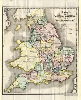
Map, hand coloured lithograph, A Map of the Meetings of
Friends in England and Wales, with railways, scale about 30
miles to 1 inch, by James Bowden, engraved by Nosworthy and
Wells, 72 Coleman Street, London, published by the Yearly
Meeting of the Society of Friends, London, 1848.
Folded and tipped in as frontispiece to An Account of the Times and Places of Holding the Meetings ... |
||

|
Quaker Map 1840s-50s | |
| map feature:- | folded (7x4) & table of symbols & up is N & lat and long scales (conical projection) & lat and long grid (1x1 degrees) & sea plain & coast shaded & county & settlements (places of meetings) & railways | |
| inscription:- |
printed upper right
A Map / OF THE / MEETINGS OF FRIENDS / IN / ENGLAND AND WALES. |
|
| inscription:- |
printed bottom left, right
James Bowden del. / Engraved & Lithographed by Nosworthy & Wells, 72 Coleman St. London. |
|
| scale:- | 1 to 1900000 ? (estimate) | |
|
||