 Fearon and Eyes 1738

|

|
|
|
item:- private collection (198) images:- © see bottom of page |
click to enlarge |
|
|
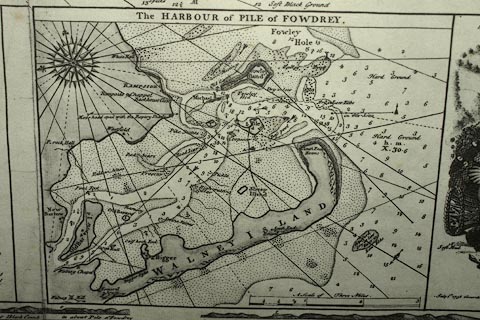
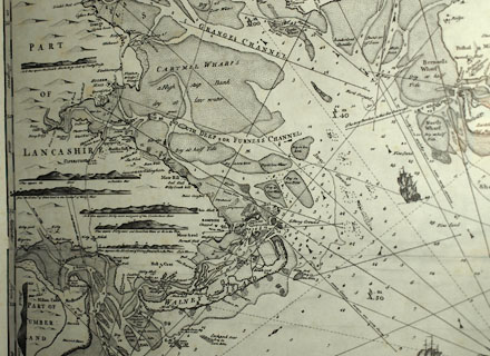
Chart, probably a reproduction, uncoloured engraving
Chart of the Sea Coast from the Harbour of Wyer to Black
Comb, by Samuel Fearon and John Eyes, engraved by Emanuel
Bowen, published by Fearon and Eyes, 1738.
There is an inset chart of the Harbout of Pile of Fowdrey. |
||

|
Fearon and Eyes 1738 | |
| map feature:- | dedication (two cartouches) & pictorial cartouche & coat of arms & compass rose & rhumb lines & up is SE (roughly) & scale line & lat and long scales & sea plain & depth soundings & tidal streams & sandbanks & anchorages (?) & galleons (well, ships) & coast line & foreshore sands & sea marks & leading lines & coast appearance & coast views & rivers (mouths) & relief & hillocks & settlements (mostly on shore) & roads (few) | |
| inscription:- |
printed lower left dedication
To / Sr. Thos. Lowther Bart. / This CHART of the SEA COAST from the / Harbour of WYER to BLACK COMB including / all Bays, Roads, Rivers, Islands, Rocks, Sand, with / proper Directions to shun all Dangers & Sail / into any Harbour, Road, &c. contained therein; / (Survey'd in 1736, 1737) is humbly Inscribed / by his Obedient Servants / Saml. Fearon & Ino. Eyes. |
|
| inscription:- |
printed lower left
July 1st. 1738 According to Act of Parliament publish'd by and for Samuel Fearon; / John Eyes. |
|
| inscription:- |
printed bottom right
Emanl. Bowen Sculpt. |
|
|
||