 Hogg 1787-89

|

|
|
|
item:- private collection (125) image:- © see bottom of page |
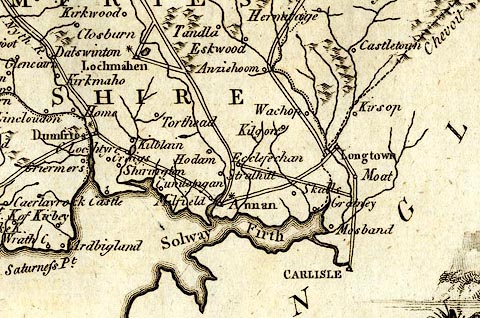
click to enlarge |
|
|
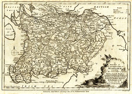
Map, uncoloured engraving, A New Map of the Southern Part
of Scotland, scale about 13 miles to 1 inch, engraved by T
Conder, published by Alexander Hogg, the Kings Arms, 16
Paternoster Row, London, 1787-89.
From the Historical Descriptions of ... The Antiquities of England and Wales. |
||

|
Hogg 1787-89 | |
| map feature:- | pictorial cartouche & compass rose & up is N & scale line & lat and long scales & sea plain & coast form lines & rivers & lakes & relief & hillocks & county & settlements & roads | |
| inscription:- |
printed title cartouche, lower right
A / NEW MAP of / the SOUTHERN PART of / SCOTLAND / Containing / the COUNTIES of / Stirling, Lanerk, Renfrew, / Linlithgow, Edinburgh, Peebles, / Haddingtoun, Berwick, Selkirk, / Roxburgh, Dumfries, Wigtoun, / Kircudbright, & Air. / Drawn from the / BEST AUTHORITIES. |
|
| inscription:- |
printed bottom, right, centre
T. Conder Sculpt. / Published by ALEXR. HOGG at the Kings Arms, No.16, PATERNOSTER ROW. |
|
| inscription:- |
printed with scale line
British Statute Miles |
|
| scale line:- | 30 miles = 59.3 mm | |
| wxh, sheet:- | 37.5x24.5cm | |
| wxh, map:- | 322x222mm | |
| scale:- | 1 to 810000 ? (1 to 814171 from scale line) | |
|
||