 Bartholomew 1880s

|

|
|
|
item:- JandMN (455_2) image:- © see bottom of page |
click to enlarge |
|
|
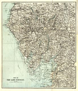
Map, colour lithograph, Map of the Lake District, scale
about 4 miles to 1 inch, by J Bartholomew, Edinburgh,
published by Bemrose and Sons, 23 Old Bailey, London and
Derby, by A B Moss, Carlisle, Cumberland, and by T Wilson,
Kendal, Westmorland, about 1881.
Tipped in as frontispiece to a Handy Guide to the English Lakes and Shap Spa. |
||

|
Bartholomew 1880s | |
| map feature:- | folded (3x3; damaged in book) & up is N & scale line & lat and long grid (?) & sea tinted & depth contours & sandbanks & coast line & foreshore sands & rivers & lakes & relief & hill hachuring & spot heights & county & settlements & roads & railways & canals | |
| inscription:- |
printed lower left
MAP OF / THE LAKE DISTRICT. |
|
| inscription:- |
printed bottom right
J. Bartholomew, Edinr. |
|
| inscription:- |
printed with scale line
Scale of Miles. |
|
| scale line:- | 8 miles = 49.6 mm | |
| wxh, folded:- | 11.5x16.5cm | |
| wxh, sheet:- | 31.5x40cm | |
| wxh, map:- | 301x357mm | |
| scale:- | 1 to 260000 (1 to 259572 from scale line) | |