 Cruchley 1856

|

|
|
|
item:- JandMN (451) image:- © see bottom of page |
click to enlarge |
|
|
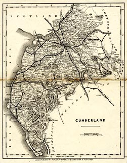
Railway map, uncoloured lithograph, Cumberland, scale about 6.5 miles to 1 inch, by George F Cruchley, 81 Fleet Street, London, about 1875? This is a late version of the Railway and Station Map of Cumberland. The railways shown are - Newcastle and Carlisle Railway, open 1836; Maryport and Carlisle Railway, open 1840-45; Lancaster and Carlisle Railway, open 1846; Whitehaven Junction Railway, open 1846-47; Furness Railway, open 1846-54; Caledonian Railway, open 1847; Cockermouth and Workington Railway, open 1847; Glasgow, Dumfries and Carlisle Railway, open 1850; Whitehaven and Furness Junction Railway, open 1849-55; Alston branch railway, open 1852; Port Carlisle Dock and Railway, open 1854; part of the Whitehaven, Cleator and Egremont Railway, open 1856-57 etc; Carlisle and Silloth Bay Railway, open 1857; Ulverstone and Lancaster Railway, open 1857; start of the Coniston Railway, open 1859-60; Border Union Railway, open 1861; Eden Valley Railway, open 1862; Cockermouth, Keswick and Penrith Railway, open 1864-65; Egremont and Sellafield branch railway, open 1869; Solway Junction Railway, open 1869-70; and the Settle and Carlisle Railway, under construction, open 1876. |
||

|
Cruchley 1856 | |
| map feature:- | up is N & scale line & lat and long scales (rectangular projection?) & sea plain & coast form lines & rivers & lakes & relief & hill hachuring & parks & county & settlements & roads & railways | |
| inscription:- |
printed lower right
CUMBERLAND |
|
| inscription:- |
printed bottom
LONDON. PUBLISHED BY G.F. CRUCHLEY, MAP-SELLER & GLOBE MAKER 81 FLEET STREET. |
|
| inscription:- |
printed above the scale line
British Statute Miles 69 1/2 to a Degree |
|
| scale line:- | 10 miles = 37.6 mm | |
| scale:- | 1 to 430000 ? (1 to 428017 from scale line) | |
| wxh, sheet:- | 22.5x30.5cm | |
| wxh, map:- | 209x264mm | |