 Baedeker 1927 map 3

|

|
|
|
item:- JandMN (447) image:- © see bottom of page |
click to enlarge |
|
|
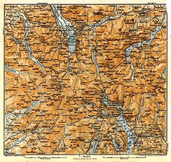
Map, The Lake District, scale about 3 miles to 1 inch, by
Wagner and Debes, Leipzig, Germany, 1927? based on the
Ordnance Survey.
Included in Baedeker's Great Britain, 8th edn 1927, tipped in opposite p.405. Shows the central Lake District only. |
||
| map type:- | Baedeker 1927 map 3 (Lakes/Cum) | |
| map feature:- | up is N & scale lines & rivers & lakes & relief & hill hachuring & hill shading & spot heights & county & settlements & roads & railways | |
| inscription:- |
printed bottom left and right
Wagner & Debes' Geogl. Estabt. Leipzig / Based on the Ordnance Survey by permission |
|
| scale line:- | 6 miles = 50.3 mm | |
| wxh, sheet:- | 22x20.5cm | |
| wxh, map:- | 200x185mm | |
| scale:- | 1 to 190000 ? (1 to 191969 from scale line) | |