 Taylor 1932 map

|

|
|
|
item:- JandMN (444_1) image:- © see bottom of page |
click to enlarge |
|
|
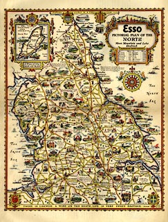
Road map, Esso Pictorial Plan of the North, by Alfred E
Taylor, published by H K McCann Co, for Anglo-American Oil
Co ie Esso, London, about 1932.
Included in Pictorial Britain, roads in Great Britain and Ireland, by Alfred E Taylor and S P B Mais. The map includes Westmorland, Cumberland, Northumberland, Durham, Yorkshire, Lancashire, and parts of Cheshire, Derbyshire, and Lincolnshire; an inset map shows the Isle of Man. |
||

|
Taylor 1932 map | |
| map feature:- | scroll cartouche (?) & coat of arms (counties) & vignettes (illustrating places all over the map) & compass rose & up is N & sea plain & coast shaded & rivers & lakes & parks & county (but no boundaries) & settlements & roads & distances from London (in a table) & inset map (Isle of Man) | |
| inscription:- |
printed upper right
ESSO / PICTORIAL PLAN OF THE / NORTH / Moor, Mountain and Lake District. |
|
| inscription:- |
printed lower right
A.E.TAYLOR 32 |
|
| wxh, sheet:- | 31x46.5cm | |
| wxh:- | map | |