 Cox 1913 map

|

|
|
|
item:- JandMN (415_1) image:- © see bottom of page |
click to enlarge |
|
|
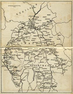
Map, uncoloured, churches of Cumberland and Westmorland,
scale about 10 miles to 1 inch, published by George Allen
and Co, Ruskin House, London, 1913.
On the end papers of County Churches, Cumberland and Westmorland, by J Charles Cox. |
||
| map type:- | Cox 1913 map (Wmd/Cmd/Cum) | |
| map feature:- | up is N & scale line & sea plain & coast line & rivers & lakes & county & settlements (where are churches) & railways | |
| inscription:- |
printed with scale line
MILES |
|
| scale line:- | 10 miles = 25.2 mm | |
| wxh, sheet:- | 16.5x20.5cm | |
| wxh, map:- | 152x197mm (approx) | |
| scale:- | 1 to 640000 ? (1 to 638629 from scale line) | |