 Rumney 1899

|

|
|
|
item:- JandMN (147_9) image:- © see bottom of page |
click to enlarge |
|
|
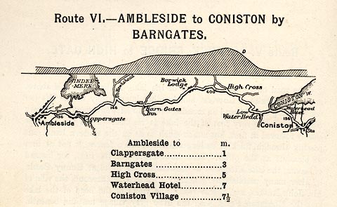
Road map, strip map, gradient diagram, and itinerary for
Route VI, Ambleside to Coniston by Barngates, Westmorland
and Lancashire, scale about 2 miles to 1 inch, by A W
Rumney, published by George Philip and Son, 32 Fleet Street,
London, and Liverpool, 1899.
On p.30 of the Cyclist's Guide to the English Lake District, by A W Rumney. |
||

|
Rumney 1899 (Roads) | |
| map feature:- | rivers & lakes & relief (gradient diagram; and marks C caution, D dangerous) & spot heights & settlements & roads | |
| inscription:- |
printed top
Route VI. - AMBLESIDE TO CONISTON by / BARNGATES. |
|
| wxh, page:- | 18x11.5cm | |
| scale:- | 1 to 126720 ? (nominal) | |