 Rumney 1899

|

|
|
|
item:- JandMN (147_3) image:- © see bottom of page |
click to enlarge |
|
|
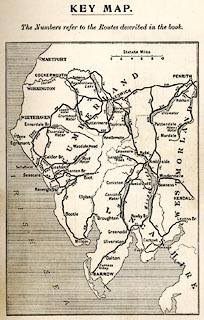
Index map, Key Map, of The Lakes, Westmorland,
Cumberland, etc, scale about 11 miles to 1 inch, published
by George Philip and Son, 32 Fleet Street, London, and
Liverpool, 1899.
On p.13 of the Cyclist's Guide to the English Lake District, by A W Rumney. |
||

|
Rumney 1899 | |
| map feature:- | up is N & scale line & sea shaded & coast line & rivers & lakes & county & settlements & roads | |
| inscription:- |
printed top
KEY MAP. / The Numbers refer to the Routes described in the book. |
|
| inscription:- |
printed with scale line
Statute Miles |
|
| scale line:- | 10 miles = 23.0 mm | |
| wxh, page:- | 11.5x18cm | |
| wxh, image:- | 87x123mm | |
| scale:- | 1 to 700000 ? (1 to 699715 from scale line) | |