 Railway Plans 1940s-60s

|

|
|
|
item:- Carlisle Library : Map 355 example 2 image:- © Carlisle Library |
click to enlarge |
|
|
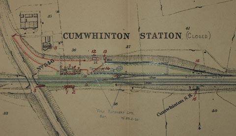
Railway plan, station plan, ?lithographic reproduction,
Cumwhinton Station, Settle and Carlisle Railway, Wetheral,
Cumberland, scale about 1 to 5300, from the London Midland
and Scottish Railway, LMS, Surveyor's Department, Euston,
London, 1960s?
The plan has annotations in pencil and ink; it shows - station and other buildings and platform, signal box 'Cumwhinton S.B.', railway bridges 'No.346', culverts, fences, footpaths, roads, rivers; railway buildings are numbered in ms, referring to a schedule; notes about the current use of land, eg 'LET TO H. ROBINSON AGT. 27.4.60'; etc. |
||

|
Railway Plans 1940s-60s | |
| map feature:- | up is NW & scale line & rivers & settlements & roads & railways | |
| inscription:- |
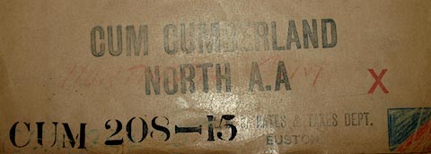
stamped & stencilled folder
CUM CUMBERLAND / NORTH A.A / CUM 208-15 / L.M.S. RATES & TAXES DEPT. EUSTON. |
|
| inscription:- |
top of map
L. M. & S. R. RATING PLAN |
|
| inscription:- |
map feature label
CUMWHINTON STATION (CLOSED) 'Closed' added in pencil |
|
| inscription:- |
with scale line
Scale, 2 Chains to an Inch |
|
| scale line:- | 70+1 chains = 267.2 mm | |
| scale line:- | 1500+100 feet = 308.1 mm | |
| wxh, folder:- | 23x35.5cm | |
| wxh, sheet:- | 49x33cm | |
| scale:- | 1 to 5300 ? (1 to 5345 from scale line) | |
|
image:- © Carlisle Library |
|
|