 Trade Card Maps 1860s-90s

|

|
|
|
item:- Carlisle Library : Map 108 image:- © Carlisle Library |
click to enlarge |
|
|
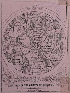
Trade card, folded, uncoloured engraving, advertising The
Queen's Hotel, Ambleside, Westmorland, issued by John Brown,
about 1870s.
The cover has a print of the hotel and a map; the reverse has descriptive text. The circular map is centred on Ambleside, scale about 5.5 miles to 1 inch; the same map has been found on other trade cards. |
||

|
Trade Card Maps 1860s-90s | |
| inscription:- |
printed front cover
AMBLESIDE, WINDERMERE / The Queen's Hotel, / The only Hotel in Ambleside that Commands / A View of Windermere Lake. royal arms |
|
| inscription:- |
printed reverse text
... LAKE SIDE HOTEL, / ADJOINING THE / Lake Side Railway Station Steamboat Pier, / ... / JOHN BROWN, Proprietor, / QUEEN'S HOTEL, AMBLESIDE. |
|
| inscription:- |
printed title below map
MAP OF THE VICIINITY OF AMBLESIDE |
|
| map feature:- | up is N & scale line & rivers & lakes & relief & hill hachuring & county & settlements & roads & railways | |
| inscription:- |
printed with scale line
Scale of Miles |
|
| scale line:- | 8 miles = 38.1 mm | |
| wxh, folded:- | 8x11cm | |
| wxh, unfolded:- | 23.5x11cm | |
| diam, map:- | 70mm | |
| scale:- | 1 to 340000 ? (1 to 337920 from scale line, assuming a statute mile) | |