 Paterson 1766

|

|
|
|
item:- British Library : K.Top.V.107 image:- © see bottom of page |
|
|
|
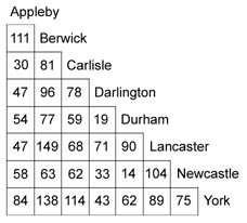
Table of distances, A Scale of Distances of the Principal
Cities and Towns in England, by Daniel Paterson, published
London, 1766
An inset map shows the towns on an outline of England, scale about 34 miles to 1 inch; in the north this includes Carlisle, Appleby, Berwick, Newcastle, Durham, Lancaster, Darlington, York. |
||

|
Paterson 1766 | |
| inscription:- |
printed upper right of table
A SCALE OF DISTANCES OF THE /PRINCIPAL CITIES & TOWNS IN ENGLAND / Giving inall 4560 distances in Measured Miles / By Daniel Paterson. |
|
| inscription:- |
printed bottom
Publish'd according to Act of Parliament, April 1766, for ye Author & Sold at Austin's Print Warehouse in Bond Street by Mr. Parker in Cornhill, & Mr. Nourse / Bookseller to his Majesty in ye Strand. Price 5s. |
|
| inscription:- |
printed upper right, inset map
An Outline of England with / the Situation of those Places / whose distances are Calculated / in the Adjoining Scale. |
|
| wxh, sheet:- | 74x54.5cm | |
| wxh, map:- | 251x320mm | |
| scale:- | 1 to 2200000 ? (estimated) | |