 Clarke 1787 map

|

|
|
|
item:- Armitt Library : A6615.7 image:- © see bottom of page |
click to enlarge |
|
|
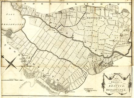
Map, uncoloured engraving, A Map of the Roads etc between
Keswick, and Broadwater, ie Bassenthwaite Lake, Cumberland,
scale about 9 miles to 1 inch, drawn and published by James
Clarke, Penrith and London, 1789.
Plate 7, folded and tipped in opposite p.95 of A Survey of the Lakes of Cumberland, Westmorland and Lancashire, by James Clarke, 2nd edn 1789. |
||

|
Clarke 1787 map | |
| map feature:- | folded (5x2; crumpled and torn) & compass rose & up is SW & scale line & rivers & lakes & woods & trees & settlements & roads | |
| inscription:- |
printed upper right
Plate 7 |
|
| inscription:- |
printed title cartouche, lower right
A / MAP / of the / ROADS &c. / between / KESWICK, / and BROADWATER. / Surveyed by JAMES CLARKE. |
|
| inscription:- |
printed with scale line
A Scale of Chains. |
|
| scale line:- | 45 chains = 131.6 mm (roughly) | |
| wxh, sheet:- | 82.5x62.5cm (?) | |
| wxh, map:- | 820x582mm (?) | |
| scale:- | 1 to 6900 ? (1 to 6879 from scale line) | |