 Clarke 1787 map

|

|
|
|
item:- Armitt Library : A6615.2 image:- © see bottom of page |
click to enlarge |
|
|
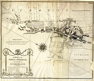
Town plan, uncoloured engraving, A Map of the Town of
Penrith in the County of Cumberland, by James Clarke,
engraved by Samuel John Neele, 352 Strand, London, published
by James Clarke, London, 1789.
Plate 2, folded and tipped in opposite p.14 of A Survey of the Lakes of Cumberland, Westmorland and Lancashire, by James Clarke, 2nd edn 1789. Judging by one of the the tables of symbols the map is intended to be coloured. |
||

|
Clarke 1787 map | |
| map feature:- | folded (4x2; crumpled and torn) & table of symbols & compass rose & up is SW (WSW) & rivers & settlements & roads & streets & gardens & constablewicks | |
| inscription:- |
printed upper right
Plate 2 |
|
| inscription:- |
printed title cartouche, lower left
A MAP of the / TOWN of PENRITH, / in the COUNTY of / CUMBERLAND. / ... / Surveyed by JAMES CLARKE. / LONDON / Engraved by Saml. Jno. Neele, 352 Strand. |
|
| wxh, sheet:- | 57.5x50cm | |
| wxh, map:- | 557x470mm | |