 Otley 1818

|

|
|
|
item:- Armitt Library : A1141.1 image:- © see bottom of page |
click to enlarge |
|
|
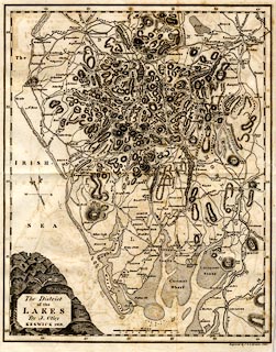
Map, uncoloured engraving, The District of the Lakes,
scale about 4 miles to 1 inch, by Jonathan Otley, Keswick,
Cumberland, 1818, engraved by J and G Menzies, Edinburgh,
published by R Lough and Co, Chronicle Office, Finkle
Street, Kendal, and others, 1820.
Tipped in as frontispiece to The Tourist's New Guide, by William Green. |
||

|
Otley 1818 | |
| map feature:- | folded (3x2) & plain cartouche & north point & magnetic deviation (26d W) & scale line & lat and long scales & sea plain & coast shaded & rivers & lakes & relief & hill hachuring & table of heights & county & settlements & roads & canals | |
| inscription:- |
printed plain cartouche, lower left
The District / of the / LAKES / By J. Otley / KESWICK 1818. |
|
| inscription:- |
printed bottom right
Engraved by J. & G. Menzies, Edinr. |
|
| scale line:- | 10 miles = 60.7 mm | |
| scale:- | 1 to 270000 ? (1 to 265131 from scale line) | |
| wxh, sheet:- | 29x42cm | |
| wxh, map:- | 256x321mm | |