 Smith 1752

|

|
|
|
item:- Carlisle Library : Map 121 image:- © Carlisle Library |
click to enlarge |
|
|
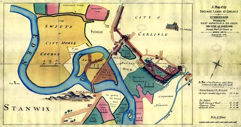
Map, hand coloured engraving, or manuscript? Map of the
Soccage Lands at Carlisle, scale about 27 ins to 1 mile, by
George Smith, 1752.
Includes a town plan of Carlisle. |
||

|
Smith 1752 | |
| map feature:- | north point & up is SE (SSEbyE) & scale line & rivers & bridges & settlements & roads | |
| inscription:- |
printed upper right
A Map of the / SOCCAGE LANDS AT CARLISLE / IN / CUMBERLAND / Belonging to the / RIGHT HONOURABLE HIS GRACE / THE DIKE OF PORTLAND. / Survey'd, Plan'd and Colour'd by / GEORGE SMITH, / August 26, 1752. |
|
| inscription:- |
printed with scale line
Scale of Chains. |
|
| scale line:- | 16 chains = 135.7 mm | |
| wxh, sheet:- | 89x49cm | |
| wxh, map:- | 689x451mm | |
| scale:- | 1 to 2400 ? (1 to 2372 from scale line) | |
|
images:- © Carlisle Library |
|
|
|
||
|
||