 Howard 1790s

|

|
|
|
item:- Armitt Library : A214.1 image:- © see bottom of page |
click to enlarge |
|
|
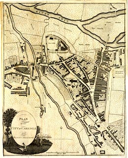
Town plan, uncoloured engraving, Plan of the City of
Carlisle and Places Adjacent, Cumberland, scale about 19
inches to 1 mile, probably by J Howard, 1793 and engraved by
James Lowes, published by Francis Jollie and Sons, Carlisle,
Cumberland, 1811.
Frontispiece to a guide book, Jollie's Cumberland Guide and Directory. |
||

|
Howard 1790s | |
| map feature:- | folded (3x4; badly torn, creased, etc) & oval cartouche & pictorial cartouche & north point & up is N & scale line & rivers & settlements & roads & streets | |
| inscription:- |
printed oval cartouche, lower left
PLAN / of the / CITY of CARLISLE / and / PLACES ADJACENT parkland scene, and a man studying a roman altar |
|
| inscription:- |
printed with scale line
Scale of Yards |
|
| scale line:- | 300 yards = 83.9 mm | |
| wxh, sheet:- | 32.5x40.5cm | |
| wxh, map:- | 313x396mm | |
| scale:- | 1 to 3300 ? (1 to 3270 from scale line) | |