 Crawford 1804

|

|
|
|
item:- Carlisle Library : Map 316 image:- © Carlisle Library |
click to enlarge | |
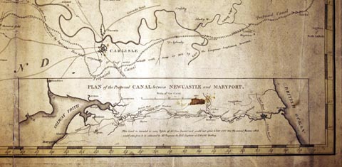
| Illustration of part of map only. | ||
|
Map, hand coloured engraving, one sheet of a Map of
Dumfriesshire, scale about 1 inch to 1 mile, by William
Crawford, engraved by Kirkwood and Sons, Edinburgh, fancy
lettering designed by George Paton, published 1804.
Some topography of the north part of Cumberland is shown, including Hadrian's Wall, Carlisle, and the proposed Tyne Solway Canal. There is an inset Plan of the Proposed Canal between Newcastle and Maryport, the Tyne Solway Canal, scale about 8.5 miles to 1 inch, which was put forward by William Chapman, 1795-96. The map is the SE sheet of a four sheet map of the county. |
||

|
Crawford 1804 | |
| map feature:- | up is N & lat and long scales & sea plain & coast form lines & rivers & relief & hill hachuring & woods & parks & county & parishes (?) & settlements & roads & canals & inset map | |
| inscription:- |
printed pictorial cartouche, upper right, NE sheet
Map / of / DUMFRIES-SHIRE / from an / Actual Survey / By / WM. CRAWFORD. / Engraved by Kirkwood & Sons / Edinburgh girl holding a banner |
|
| inscription:- |
printed dedication, lower right
To / His Grace / HENRY, DUKE OF BUCCLEUCH, / K.G. &c. &c. &c. / This Map / Is with the greatest RESPECT & GRATITUDE Inscribed / By His Grace's most obedient & most humble servant / William Crawford. // The / ornamental writing designed / by / GEO. PATON / Teacher, / Edinburgh. |
|
| inscription:- |
printed label with Hadrian's Wall
Part of the Roman Wall built by Emperor Adrian in 172 to connect the Chain of Posts which had about 40 years before been established by Agricola. This Wall originally of Turf was rebuilt with Stone in 208 by Emperor Septimus Severus. |
|
| inscription:- |
printed top of inset map
LINE of the proposed CANAL between NEWCASTLE and MARYPORT. |
|
| inscription:- |
inset map: printed with scale line
Scale of the Canal |
|
| scale line:- | 20 miles = 61.2 mm | |
| wxh, sheet:- | 77.5x66cm | |
| wxh, map:- | 735x614mm | |
| scale:- | 1 to 64000 ? (1 to 64123, from 15 minutes latitude = 434 mm) | |
| scale:- | 1 to 530000 ? (1 to 525929 from its scale line) | |