 Collins 1693

|

|
|
|
item:- Carlisle Library : Map 251 image:- © Carlisle Library |
click to enlarge | |
| NB: this image is scanned from a photocopy. The Selotape repair and other damage has been erased. This is not a 'reliable' image. | ||
|
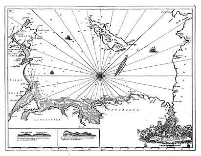
Chart, uncoloured engraving, the Irish Sea, scale about
6.5 nautical miles to 1 inch, by Captain Greenville Collins,
1693, published by W and J Mount and T Page, London, 1785.
Plate 29 from Great Britain's Coasting Pilot. The sailing directions relevant to this sheet are on page 8 (1753 edition) and for Cumbria only have:- White Haven / A little to the northward of St. Bees Head lieth White Haven, being a good dry Pier, where great Ships take in Sea-Coals, and carry them to Dublin in Ireland. This place belongeth to Sir John Lowther. / ... |
||

|
Collins 1693 | |
| map feature:- | dedication & coat of arms & compass rose & up is W & rhumb lines & scale line & latitude scale & sea plain & galleons & depth soundings & anchorages & coast shaded (inland) & foreshore sands & sandbanks & coast views & county & settlements (few) | |
| inscription:- |
printed dedication, scroll cartouche, lower right
To the Honble. SR. JOHN LOWTHER Bart. On of the Commissioners / for Executing the Office of Lord High Admiral of England decorated with Neptune, horses, coat of arms, etc |
|
| inscription:- |
printed with scale line
A Scale of English Miles |
|
| scale line:- | 15 nautical miles = 60.3 mm | |
| wxh, sheet:- | 62.5x52.5cm | |
| wxh, plate:- | 573x456mm (?) | |
| wxh, map:- | 557x441mm | |
| scale:- | 1 to 460000 ? (1 to 460991 from scale line, assuming a 'standard' nautical mile) | |
|
|
notes | |