 Railway Clearing House 1900s-10s

|

|
|
|
item:- Carlisle Library : Map 113 image:- © Carlisle Library |
click to enlarge |
|
|
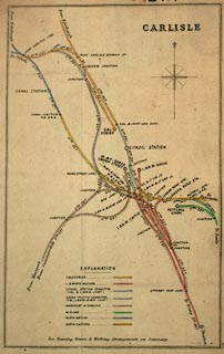
Railway map, hand coloured lithograph, Carlisle, probably
published by John Airey, Railway Clearing House, London,
about 1914?
The railways shown include the - Caledonian Railway; Lancaster and Carlisle Railway; Maryport and Carlisle Railway; Settle and Carlisle Railway; Newcastle and Carlisle Railway; Border Union Railway; and Port Carlisle Dock and Railway. |
||

|
Railway Clearing House 1900s-10s | |
| map feature:- | north point & up is N & table of symbols & railways | |
| inscription:- |
printed
CARLISLE |
|
| wxh, sheet:- | 16.5x26.5cm | |
| wxh, map:- | 136x215mm | |