 Midland Railway 1870s

|

|
|
|
item:- Carlisle Library : Map 98 image:- © Carlisle Library |
click to enlarge |
|
|
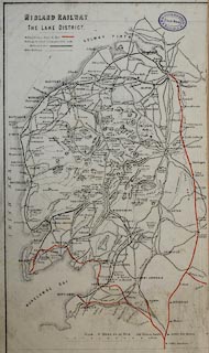
Railway map, colour lithograph, Midland Railway, The Lake
District, scale about 8 miles to 1 inch, published by the
Midland Railway, 1870s?
The railways shown are - Newcastle and Carlisle Railway; Maryport and Carlisle Railway; Lancaster and Carlisle Railway; Kendal and Windermere Railway; Whitehaven Junction Railway; Furness Railway; Cockermouth and Workington Railway; Glasgow, Dumfries and Carlisle Railway; Whitehaven and Furness Junction Railway; Port Carlisle Dock and Railway; Alston branch railway; Whitehaven, Cleator and Egremont Railway; Carlisle and Silloth Bay Railway; Ulverstone and Lancaster Railway; Coniston Railway; Border Union Railway; Low Gill and Ingleton branch railway; South Durham and Lancashire Union Railway; Eden Valley Railway; Cockermouth, Keswick and Penrith Railway; Egremont and Sellafield branch railway; Lakeside branch railway; Solway Junction Railway; and Settle and Carlisle Railway. |
||

|
Midland Railway 1870s | |
| map feature:- | table of symbols & north point & up is N (NNW) & scale line & sea plain & coast form lines & rivers & lakes & relief & hill hachuring & parks & settlements & roads & railways (MR in red) | |
| inscription:- |
printed upper left
MIDLAND RAILWAY / THE LAKE DISTTRICT. |
|
| inscription:- |
printed with scale line
SCALE - 8 MILES TO AN INCH |
|
| scale line:- | 20 miles = 62.5 mm | |
| wxh, sheet:- | 17.5x28cm | |
| wxh, map:- | 152x262mm | |
| scale:- | 1 to 510000 ? (1 to 514990 from scale line) | |