 Dickinson and Sopwith 1828

|

|
|
|
item:- Carlisle Library : Map 49 image:- © Carlisle Library |
click to enlarge | |
| Illustration of part of map only. | ||
|
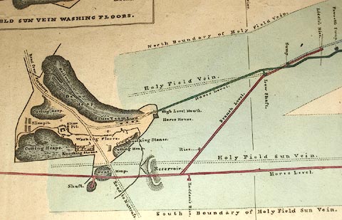
Mine plan, and section, hand coloured engraving,
Holyfield Sun Vein Lead Mine, Nattrass, Alston Moor,
Cumberland, scale about 37 ins to 1 mile, by J Dickinson and
T Sopwith, 1828.
Notice that the north point is labelled 'Magnetic Meridian'. There is an inset plan of the mine's washing floors, which locates the mine relative to Nattrass Gill Bridge. This copy of the plan was given to Miss Sopwith by her cousin T Sopwith. |
||
| map type:- | Dickinson and Sopwith 1828 | |
| inscription:- |
printed upper centre
SECTION OF THE STRATA / AND SUBTERRANEOUS WORKINGS OF / HOLYFIELD SUN VEIN LEAD MINE. |
|
| inscription:- |
printed lower centre
PLAN OF HOLY-FIELD LEAD MINES IN THE MANOR OF ALSTON-MOOR : WITH A SECTION OF THE STRATA |
|
| inscription:- |
printed bottom left, centre, right
Surveyed by J. Dickinson & T. Sopwith / July 1828 / Engraved by T. Sopwith |
|
| inscription:- |
ms bottom right
Miss Sopwith / from her affectionate Cousin / T.S. |
|
| inscription:- |
printed above scale line
Scale of Chains. |
|
| scale line:- | 3+1 chains = 50.2 mm | |
| inscription:- |
printed above scale line
Scale of Fathoms. |
|
| scale line:- | 30+10 fathoms = 41.1 mm | |
| wxh, sheet:- | 60x35.5cm | |
| wxh, map:- | 589x308mm | |
| scale:- | 1 to 1700 ? (1 to 1603 and 1 to 1780 from two scale lines) | |

|
||