 Gents Mag

|

|
|
|
item:- Carlisle Library : Map 43 image:- © Carlisle Library |
click to enlarge |
|
|
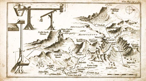
Map, uncoloured engraving, perspective view, Caudbeck
Fells ie Caldbeck Fells, scale about 1+ miles to 1 inch,
published in the Gentleman's Magazine, 1747.
The map was published November 1747 opposite p.524, with accompanying text pp.522-524. |
||

|
Gents Mag (1747 map) | |
| map feature:- | compass rose & up is W & scale line & rivers & lakes & relief & hill drawings & settlements & mines | |
| inscription:- |
printed top right
Gent. Mag. 1747. p.524. |
|
| inscription:- |
printed heading of article with map
A Journey to CAUDEBEC FELLS, with a Map and Description of the same. |
|
| scale line:- | 2 miles = 41.1 m | |
| wxh, sheet:- | 21x12.5cm | |
| wxh, map:- | 189x107mm | |
| scale:- | 1 to 78000 ? (1 to 78314 from scale line, assuming a statute mile) | |