 Howard 1790s

|

|
|
|
item:- Carlisle Library (4_4) image:- © Carlisle Library |
click to enlarge |
|
|
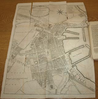
Town plan, uncoloured engraving, Plan of the Town and
Harbour of Whitehaven, scale about 26 inches to 1 mile, by J
Howard, 1790, published by F Jollie and Sons, Carlisle,
Cumberland, 1811.
Tipped in opposite part 2 p.25 of Jollie's Cumberland Guide and Directory. |
||

|
Howard 1790s | |
| map feature:- | folded (4x3; creased and torn) & floral cartouche & compass rose & up is W (WSWbyW) & scale line & sea plain & coast form lines & rivers & woods & parks (?) & settlements & roads & streets | |
| inscription:- |
printed upper left of centre
A / PLAN of the TOWN & HARBOUR / OF / WHITEHAVEN / in the County of / CUMBERLAND / from an actual Survey Anno 1811 / by J. Howard. |
|
| inscription:- |
printed with scale line
A Scale of 12 Chains, or 264 Yards |
|
| scale line:- | 264 yards = 99.2 mm | |
| wxh, sheet:- | 43.5x55.5cm | |
| wxh, map:- | 412x512mm | |
| scale:- | 1 to 2400 ? (1 to 2435 from scale line) | |