 Howard 1790s

|

|
|
|
item:- Carlisle Library (4_3) image:- © Carlisle Library |
click to enlarge |
|
|
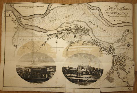
Town plan, uncoloured engraving, Plan of the Town and
Harbour of Workington, scale about 16 inches to 1 mile,
probably by J Howard, 1793, published by F Jollie and Sons,
Carlisle, Cumberland, 1811.
Tipped in opposite part 2 p.17 of Jollie's Cumberland Guide and Directory. |
||

|
Howard 1790s | |
| map feature:- | folded (4x2; torn, etc) & vignettes (SE and NE views of the Hall) & north point & up is N & scale line & rivers & relief (some) & hill hachuring & woods & settlements & roads & streets | |
| inscription:- |
printed upper right
PLAN / of the / TOWN and HARBOUR / of / WORKINGTON / From an actual Survey Anno.1811. |
|
| inscription:- |
printed with scale line
Scale of Yards |
|
| scale line:- | 400 yards = 90.4 mm (about) | |
| wxh, sheet:- | 43x27.5cm | |
| wxh, map:- | 413x262mm (approx) | |
| scale:- | 1 to 4000 ? (1 to 4046 from scale line) | |